Aprica geodata
Aprica (Lombardy) is a seat of a third-order administrative division; located in Italy in Europe/Rome (GMT+2) time zone. With population of 1,585 people, there are 4933 cities with bigger population in this country. Compared to other cities in Italy, 95% of cities are located further ↓South; 66.4% of cities are located further →East and 98.5% of cities have lower elevation than Aprica. Note1


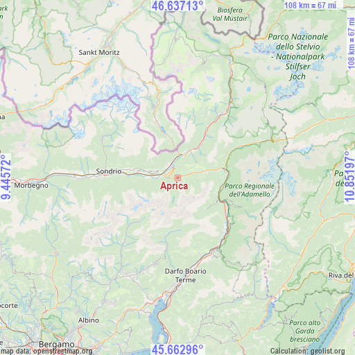
Aprica GPS coordinates[2]
46° 9' 7.92" North, 10° 8' 55.824" East
| Map corner | latitude | longitude |
|---|---|---|
| Upper-left | 46.63713°, | 9.44572° |
| Center: | 46.1522°, | 10.14884° |
| Lower-right: | 45.66296°, | 10.85197° |
| Map W x H: | 108.3×108.3 km | = 67.3×67.3mi |
| max Lat: | 47.04031° ⇑5% North |
| Aprica: | 46.1522° |
| min Lat: | ⇓95% South 35.50142° |
| min Long | Aprica | max Long |
| 6.69888° | 10.14884° | 18.48682° |
| W 33.6%⇐ | ⇒66.4% E |
Elevation
Elevation of Aprica is 1176 m = 3858 ft, and this is 869.3 m = 2852 ft above average elevation for this country.
| Max E: |
2085 m = 6841 ft | 1.5% |
| Aprica | 1176 m 3858 ft | |
| Avg. | 306.7 m = 1006 ft | |
Min E: |
-4 m = -13 ft | 98.5% |
See also: Italy elevation on elevation.city.
Geographical zone
Aprica is located in North temperate zone (between Tropic of Cancer and the Arctic Circle). Distance of this North polar circle is 2269.5 km =1410.2 mi to North.| Distance of | km | miles | from Aprica |
|---|---|---|---|
| North Pole | 4875.4 | 3029.4 | to North |
| Arctic Circle | 2269.5 | 1410.2 | to North |
| Tropic Cancer | 2525.7 | 1569.4 | to South |
| Equator | 5131.6 | 3188.6 | to South |


Nearby cities:
15 places around Aprica: (largest is in red/bold)
• Bianzone
4.9 km =3 mi,  321°
321°
• Castello dell'Acqua
10.3 km =6.4 mi,  265°
265°
• Castionetto
11.4 km =7.1 mi,  283°
283°
• Chiuro
12.7 km =7.9 mi, 277°
• Corteno Golgi
7.5 km =4.7 mi,  77°
77°
• Lovero
10.7 km =6.6 mi,  34°
34°
• Ponte in Valtellina
13.4 km =8.3 mi, 280°
• San Giacomo
9.6 km =6 mi, 275°
• Sernio
9.1 km =5.7 mi, 28°
• Teglio
6.9 km =4.3 mi,  288°
288°
• Tirano
7.1 km =4.4 mi,  9°
9°
• Tovo di Sant'Agata
12.8 km =8 mi,  36°
36°
• Tresenda
5.4 km =3.4 mi, 280°
• Vervio
13.2 km =8.2 mi, 32°
• Villa
5.9 km =3.7 mi,  348°
348°
Sources, notices
• [Note1] Compared only with cities in Italy existing in our database
• [Src1] Map data: © OpenStreetMap contributors (CC-BY-SA)
• [Src2] Other city data from geonames.org with taken over terms of usage.
• [Src3] Geographical zone / Annual Mean Temperature by Robert A. Rohde @ Wikipedia
