Chiuduno geodata
Chiuduno (Lombardy) is a seat of a third-order administrative division; located in Italy in Europe/Rome (GMT+2) time zone. With population of 5,434 people, there are 1805 cities with bigger population in this country. Compared to other cities in Italy, 79.1% of cities are located further ↓South; 69.3% of cities are located further →East and 53% of cities have higher elevation than Chiuduno. Note1


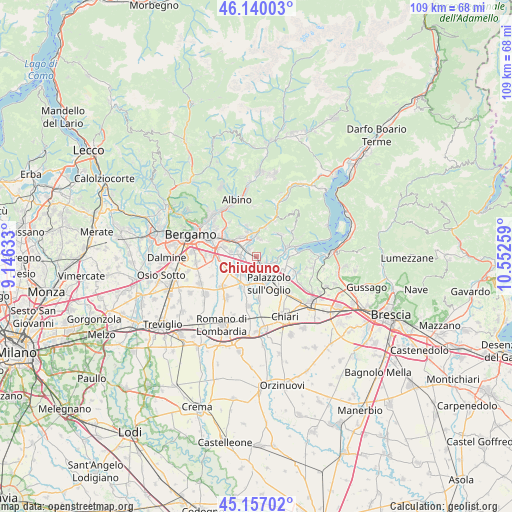
Chiuduno GPS coordinates[2]
45° 39' 2.448" North, 9° 50' 58.056" East
| Map corner | latitude | longitude |
|---|---|---|
| Upper-left | 46.14003°, | 9.14633° |
| Center: | 45.65068°, | 9.84946° |
| Lower-right: | 45.15702°, | 10.55259° |
| Map W x H: | 109.3×109.3 km | = 67.9×67.9mi |
| max Lat: | 47.04031° ⇑20.9% North |
| Chiuduno: | 45.65068° |
| min Lat: | ⇓79.1% South 35.50142° |
| min Long | Chiuduno | max Long |
| 6.69888° | 9.84946° | 18.48682° |
| W 30.7%⇐ | ⇒69.3% E |
Elevation
Elevation of Chiuduno is 216 m = 709 ft, and this is 90.7 m = 298 ft below average elevation for this country.
| Max E: |
2085 m = 6841 ft | 53% |
| Avg. | 306.7 m = 1006 ft | |
| Chiuduno | 216 m = 709 ft | |
Min E: |
-4 m = -13 ft | 47% |
See also: Italy elevation on elevation.city.
Geographical zone
Chiuduno is located in North temperate zone (between Tropic of Cancer and the Arctic Circle). Distance of this North polar circle is 2325.3 km =1444.9 mi to North.| Distance of | km | miles | from Chiuduno |
|---|---|---|---|
| North Pole | 4931.2 | 3064.1 | to North |
| Arctic Circle | 2325.3 | 1444.9 | to North |
| Tropic Cancer | 2470 | 1534.8 | to South |
| Equator | 5075.9 | 3154 | to South |


Nearby cities:
15 places around Chiuduno: (largest is in red/bold)
• Bolgare
3.4 km =2.1 mi,  233°
233°
• Calcinate
5.3 km =3.3 mi, 229°
• Carobbio
2.1 km =1.3 mi,  315°
315°
• Carobbio degli Angeli
2.3 km =1.4 mi, 315°
• Castelli Calepio
5 km =3.1 mi,  146°
146°
• Celatica-Tolari
4.4 km =2.7 mi,  68°
68°
• Costa di Mezzate
4.4 km =2.7 mi,  287°
287°
• Gandosso
3.2 km =2 mi, 73°
• Gorlago
3.3 km =2.1 mi, 321°
• Grumello del Monte
2.6 km =1.6 mi,  130°
130°
• Montello
4.2 km =2.6 mi,  304°
304°
• Tagliuno
4.7 km =2.9 mi,  101°
101°
• Telgate
2.5 km =1.6 mi,  180°
180°
• Trescore Balneario
4.9 km =3 mi,  352°
352°
• Zandobbio
4 km =2.5 mi,  9°
9°
Sources, notices
• [Note1] Compared only with cities in Italy existing in our database
• [Src1] Map data: © OpenStreetMap contributors (CC-BY-SA)
• [Src2] Other city data from geonames.org with taken over terms of usage.
• [Src3] Geographical zone / Annual Mean Temperature by Robert A. Rohde @ Wikipedia
