Canistro Inferiore geodata
Canistro Inferiore (Abruzzo) is a seat of a third-order administrative division; located in Italy in Europe/Rome (GMT+2) time zone. With population of 726 people, there are 8116 cities with bigger population in this country. Compared to other cities in Italy, 70.9% of cities are located further ↑North; 72.5% of cities are located further ←West and 82.1% of cities have lower elevation than Canistro Inferiore. Note1


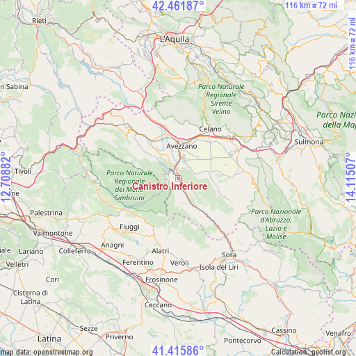
Canistro Inferiore GPS coordinates[2]
41° 56' 27.636" North, 13° 24' 42.984" East
| Map corner | latitude | longitude |
|---|---|---|
| Upper-left | 42.46187°, | 12.70882° |
| Center: | 41.94101°, | 13.41194° |
| Lower-right: | 41.41586°, | 14.11507° |
| Map W x H: | 116.3×116.3 km | = 72.3×72.3mi |
| max Lat: | 47.04031° ⇑70.9% North |
| Canistro Inferiore: | 41.94101° |
| min Lat: | ⇓29.1% South 35.50142° |
| min Long | Canistro Inferi | max Long |
| 6.69888° | 13.41194° | 18.48682° |
| W 72.5%⇐ | ⇒27.5% E |
Elevation
Elevation of Canistro Inferiore is 556 m = 1824 ft, and this is 249.3 m = 818 ft above average elevation for this country.
| Max E: |
2085 m = 6841 ft | 17.9% |
| Canistro Inferiore | 556 m 1824 ft | |
| Avg. | 306.7 m = 1006 ft | |
Min E: |
-4 m = -13 ft | 82.1% |
See also: Italy elevation on elevation.city.
Geographical zone
Canistro Inferiore is located in North temperate zone (between Tropic of Cancer and the Arctic Circle). Distance of this Northern Tropic circle is 2057.5 km =1278.5 mi to South.| Distance of | km | miles | from Canistro Inferiore |
|---|---|---|---|
| North Pole | 5343.7 | 3320.4 | to North |
| Arctic Circle | 2737.8 | 1701.2 | to North |
| Tropic Cancer | 2057.5 | 1278.5 | to South |
| Equator | 4663.4 | 2897.7 | to South |


Nearby cities:
15 places around Canistro Inferiore: (largest is in red/bold)
• Antrosano
13.7 km =8.5 mi,  359°
359°
• Avezzano
9.9 km =6.2 mi,  6°
6°
• Capistrello
3.7 km =2.3 mi,  339°
339°
• Cappadocia
13.3 km =8.3 mi,  303°
303°
• Cappelle
14.2 km =8.8 mi,  349°
349°
• Castellafiume
8.4 km =5.2 mi,  309°
309°
• Cese
9.5 km =5.9 mi, 348°
• Civita d'Antino
7.9 km =4.9 mi,  140°
140°
• Civitella Roveto
3.2 km =2 mi,  162°
162°
• Filettino
9.1 km =5.7 mi,  232°
232°
• La Grancia
9 km =5.6 mi,  168°
168°
• Luco dei Marsi
5.5 km =3.4 mi,  68°
68°
• Morino
9.3 km =5.8 mi, 156°
• San Vincenzo Valle Roveto
14.8 km =9.2 mi, 136°
• Trasacco
10.2 km =6.3 mi,  79°
79°
Sources, notices
• [Note1] Compared only with cities in Italy existing in our database
• [Src1] Map data: © OpenStreetMap contributors (CC-BY-SA)
• [Src2] Other city data from geonames.org with taken over terms of usage.
• [Src3] Geographical zone / Annual Mean Temperature by Robert A. Rohde @ Wikipedia
