Capistrello geodata
Capistrello (Abruzzo) is a seat of a third-order administrative division; located in Italy in Europe/Rome (GMT+2) time zone. With population of 4,795 people, there are 2039 cities with bigger population in this country. Compared to other cities in Italy, 70.6% of cities are located further ↑North; 72.3% of cities are located further ←West and 90.5% of cities have lower elevation than Capistrello. Note1


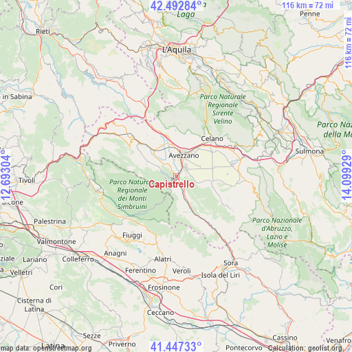
Capistrello GPS coordinates[2]
41° 58' 20.028" North, 13° 23' 46.176" East
| Map corner | latitude | longitude |
|---|---|---|
| Upper-left | 42.49284°, | 12.69304° |
| Center: | 41.97223°, | 13.39616° |
| Lower-right: | 41.44733°, | 14.09929° |
| Map W x H: | 116.2×116.2 km | = 72.2×72.2mi |
| max Lat: | 47.04031° ⇑70.6% North |
| Capistrello: | 41.97223° |
| min Lat: | ⇓29.4% South 35.50142° |
| min Long | Capistrello | max Long |
| 6.69888° | 13.39616° | 18.48682° |
| W 72.3%⇐ | ⇒27.7% E |
Elevation
Elevation of Capistrello is 732 m = 2402 ft, and this is 425.3 m = 1395 ft above average elevation for this country.
| Max E: |
2085 m = 6841 ft | 9.5% |
| Capistrello | 732 m 2402 ft | |
| Avg. | 306.7 m = 1006 ft | |
Min E: |
-4 m = -13 ft | 90.5% |
See also: Italy elevation on elevation.city.
Geographical zone
Capistrello is located in North temperate zone (between Tropic of Cancer and the Arctic Circle). Distance of this Northern Tropic circle is 2061 km =1280.6 mi to South.| Distance of | km | miles | from Capistrello |
|---|---|---|---|
| North Pole | 5340.2 | 3318.2 | to North |
| Arctic Circle | 2734.3 | 1699 | to North |
| Tropic Cancer | 2061 | 1280.6 | to South |
| Equator | 4666.9 | 2899.9 | to South |


Nearby cities:
15 places around Capistrello: (largest is in red/bold)
• Antrosano
10.3 km =6.4 mi,  6°
6°
• Avezzano
6.8 km =4.2 mi,  21°
21°
• Canistro Inferiore
3.7 km =2.3 mi,  159°
159°
• Cappadocia
10.5 km =6.5 mi,  291°
291°
• Cappelle
10.6 km =6.6 mi,  352°
352°
• Castellafiume
5.4 km =3.4 mi, 290°
• Cese
5.8 km =3.6 mi, 354°
• Civita d'Antino
11.4 km =7.1 mi,  146°
146°
• Civitella Roveto
6.9 km =4.3 mi, 160°
• Filettino
10.7 km =6.6 mi,  213°
213°
• La Grancia
12.7 km =7.9 mi,  165°
165°
• Luco dei Marsi
6.6 km =4.1 mi,  102°
102°
• Morino
13 km =8.1 mi, 157°
• Scurcola Marsicana
11.1 km =6.9 mi,  335°
335°
• Trasacco
11.4 km =7.1 mi, 98°
Sources, notices
• [Note1] Compared only with cities in Italy existing in our database
• [Src1] Map data: © OpenStreetMap contributors (CC-BY-SA)
• [Src2] Other city data from geonames.org with taken over terms of usage.
• [Src3] Geographical zone / Annual Mean Temperature by Robert A. Rohde @ Wikipedia
