Tornareccio geodata
Tornareccio (Abruzzo) is a seat of a third-order administrative division; located in Italy in Europe/Rome (GMT+2) time zone. With population of 1,317 people, there are 5580 cities with bigger population in this country. Compared to other cities in Italy, 70% of cities are located further ↑North; 81.9% of cities are located further ←West and 86.5% of cities have lower elevation than Tornareccio. Note1


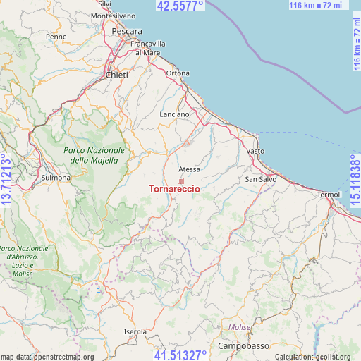
Tornareccio GPS coordinates[2]
42° 2' 15.468" North, 14° 24' 54.9" East
| Map corner | latitude | longitude |
|---|---|---|
| Upper-left | 42.5577°, | 13.71213° |
| Center: | 42.03763°, | 14.41525° |
| Lower-right: | 41.51327°, | 15.11838° |
| Map W x H: | 116.1×116.1 km | = 72.1×72.1mi |
| max Lat: | 47.04031° ⇑70% North |
| Tornareccio: | 42.03763° |
| min Lat: | ⇓30% South 35.50142° |
| min Long | Tornareccio | max Long |
| 6.69888° | 14.41525° | 18.48682° |
| W 81.9%⇐ | ⇒18.1% E |
Elevation
Elevation of Tornareccio is 643 m = 2110 ft, and this is 336.3 m = 1103 ft above average elevation for this country.
| Max E: |
2085 m = 6841 ft | 13.5% |
| Tornareccio | 643 m 2110 ft | |
| Avg. | 306.7 m = 1006 ft | |
Min E: |
-4 m = -13 ft | 86.5% |
See also: Italy elevation on elevation.city.
Geographical zone
Tornareccio is located in North temperate zone (between Tropic of Cancer and the Arctic Circle). Distance of this Northern Tropic circle is 2068.2 km =1285.1 mi to South.| Distance of | km | miles | from Tornareccio |
|---|---|---|---|
| North Pole | 5332.9 | 3313.7 | to North |
| Arctic Circle | 2727 | 1694.5 | to North |
| Tropic Cancer | 2068.2 | 1285.1 | to South |
| Equator | 4674.1 | 2904.4 | to South |


Nearby cities:
15 places around Tornareccio: (largest is in red/bold)
• Archi
6.5 km =4 mi,  335°
335°
• Atessa
4.6 km =2.9 mi,  38°
38°
• Bomba
4 km =2.5 mi,  263°
263°
• Carpineto Sinello
7.9 km =4.9 mi,  112°
112°
• Casalanguida
6.7 km =4.2 mi,  90°
90°
• Colledimezzo
6.2 km =3.9 mi,  202°
202°
• Guilmi
7 km =4.3 mi,  131°
131°
• Monte Marcone
9.6 km =6 mi,  8°
8°
• Montebello sul Sangro
9.4 km =5.8 mi,  233°
233°
• Pennadomo
8.5 km =5.3 mi,  243°
243°
• Perano
7.6 km =4.7 mi,  347°
347°
• Piane d'Archi-Quadroni
8.2 km =5.1 mi,  333°
333°
• Pietraferrazzana
8.3 km =5.2 mi, 203°
• Quadroni-Fontolfi-Impicciaturo-Maligni
8.6 km =5.3 mi, 338°
• Roccascalegna
9.3 km =5.8 mi,  287°
287°
Sources, notices
• [Note1] Compared only with cities in Italy existing in our database
• [Src1] Map data: © OpenStreetMap contributors (CC-BY-SA)
• [Src2] Other city data from geonames.org with taken over terms of usage.
• [Src3] Geographical zone / Annual Mean Temperature by Robert A. Rohde @ Wikipedia
