Archi geodata
Archi (Abruzzo) is a seat of a third-order administrative division; located in Italy in Europe/Rome (GMT+2) time zone. With population of 580 people, there are 9180 cities with bigger population in this country. Compared to other cities in Italy, 69.6% of cities are located further ↑North; 81.6% of cities are located further ←West and 74.2% of cities have lower elevation than Archi. Note1


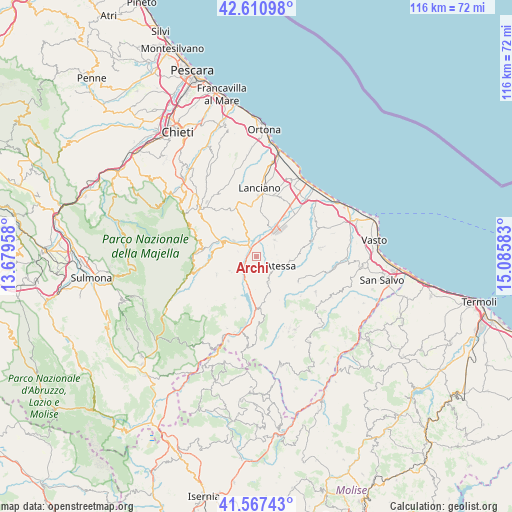
Archi GPS coordinates[2]
42° 5' 28.86" North, 14° 22' 57.72" East
| Map corner | latitude | longitude |
|---|---|---|
| Upper-left | 42.61098°, | 13.67958° |
| Center: | 42.09135°, | 14.3827° |
| Lower-right: | 41.56743°, | 15.08583° |
| Map W x H: | 116×116 km | = 72.1×72.1mi |
| max Lat: | 47.04031° ⇑69.6% North |
| Archi: | 42.09135° |
| min Lat: | ⇓30.4% South 35.50142° |
| min Long | Archi | max Long |
| 6.69888° | 14.3827° | 18.48682° |
| W 81.6%⇐ | ⇒18.4% E |
Elevation
Elevation of Archi is 442 m = 1450 ft, and this is 135.3 m = 444 ft above average elevation for this country.
| Max E: |
2085 m = 6841 ft | 25.8% |
| Archi | 442 m 1450 ft | |
| Avg. | 306.7 m = 1006 ft | |
Min E: |
-4 m = -13 ft | 74.2% |
See also: Italy elevation on elevation.city.
Geographical zone
Archi is located in North temperate zone (between Tropic of Cancer and the Arctic Circle). Distance of this Northern Tropic circle is 2074.2 km =1288.8 mi to South.| Distance of | km | miles | from Archi |
|---|---|---|---|
| North Pole | 5326.9 | 3310 | to North |
| Arctic Circle | 2721.1 | 1690.8 | to North |
| Tropic Cancer | 2074.2 | 1288.8 | to South |
| Equator | 4680.1 | 2908.1 | to South |


Nearby cities:
15 places around Archi: (largest is in red/bold)
• Altino
4.2 km =2.6 mi,  282°
282°
• Atessa
6.1 km =3.8 mi,  112°
112°
• Bomba
6.6 km =4.1 mi,  191°
191°
• Casoli
8 km =5 mi,  288°
288°
• Gessopalena
9.9 km =6.2 mi,  245°
245°
• Monte Marcone
5.4 km =3.4 mi,  48°
48°
• Pennadomo
10.9 km =6.8 mi,  206°
206°
• Perano
1.8 km =1.1 mi,  36°
36°
• Piane d'Archi-Quadroni
1.7 km =1.1 mi,  323°
323°
• Piazzano-Piana la Fara
4.7 km =2.9 mi,  29°
29°
• Quadroni-Fontolfi-Impicciaturo-Maligni
2.1 km =1.3 mi,  345°
345°
• Roccascalegna
7 km =4.3 mi,  242°
242°
• Sant'Eusanio del Sangro
9.8 km =6.1 mi,  332°
332°
• Selva
4.1 km =2.5 mi,  308°
308°
• Tornareccio
6.5 km =4 mi,  155°
155°
Sources, notices
• [Note1] Compared only with cities in Italy existing in our database
• [Src1] Map data: © OpenStreetMap contributors (CC-BY-SA)
• [Src2] Other city data from geonames.org with taken over terms of usage.
• [Src3] Geographical zone / Annual Mean Temperature by Robert A. Rohde @ Wikipedia
