Monte Marcone geodata
Monte Marcone (Abruzzo) is a populated place; located in Italy in Europe/Rome (GMT+2) time zone. With population of 765 people, there are 7846 cities with bigger population in this country. Compared to other cities in Italy, 69.3% of cities are located further ↑North; 82% of cities are located further ←West and 69.3% of cities have higher elevation than Monte Marcone. Note1


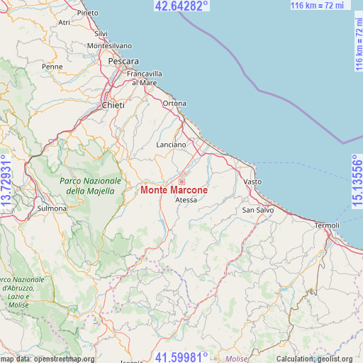
Monte Marcone GPS coordinates[2]
42° 7' 24.456" North, 14° 25' 56.748" East
| Map corner | latitude | longitude |
|---|---|---|
| Upper-left | 42.64282°, | 13.72931° |
| Center: | 42.12346°, | 14.43243° |
| Lower-right: | 41.59981°, | 15.13556° |
| Map W x H: | 116×116 km | = 72.1×72.1mi |
| max Lat: | 47.04031° ⇑69.3% North |
| Monte Marcone: | 42.12346° |
| min Lat: | ⇓30.7% South 35.50142° |
| min Long | Monte Marcone | max Long |
| 6.69888° | 14.43243° | 18.48682° |
| W 82%⇐ | ⇒18% E |
Elevation
Elevation of Monte Marcone is 101 m = 331 ft, and this is 205.7 m = 675 ft below average elevation for this country.
| Max E: |
2085 m = 6841 ft | 69.3% |
| Avg. | 306.7 m = 1006 ft | |
| Monte Marcone | 101 m = 331 ft | |
Min E: |
-4 m = -13 ft | 30.7% |
See also: Italy elevation on elevation.city.
Geographical zone
Monte Marcone is located in North temperate zone (between Tropic of Cancer and the Arctic Circle). Distance of this Northern Tropic circle is 2077.8 km =1291.1 mi to South.| Distance of | km | miles | from Monte Marcone |
|---|---|---|---|
| North Pole | 5323.4 | 3307.8 | to North |
| Arctic Circle | 2717.5 | 1688.6 | to North |
| Tropic Cancer | 2077.8 | 1291.1 | to South |
| Equator | 4683.7 | 2910.3 | to South |


Nearby cities:
15 places around Monte Marcone: (largest is in red/bold)
• Altino
8.6 km =5.3 mi,  252°
252°
• Archi
5.4 km =3.4 mi,  228°
228°
• Atessa
6.1 km =3.8 mi,  165°
165°
• Castel Frentano
10.5 km =6.5 mi,  323°
323°
• Mozzagrogna
10 km =6.2 mi,  4°
4°
• Paglieta
7.2 km =4.5 mi,  54°
54°
• Perano
3.7 km =2.3 mi,  235°
235°
• Piane d'Archi-Quadroni
5.6 km =3.5 mi, 246°
• Piazzano-Piana la Fara
1.9 km =1.2 mi,  285°
285°
• Quadroni-Fontolfi-Impicciaturo-Maligni
4.9 km =3 mi, 251°
• Sant'Egidio
7.4 km =4.6 mi,  37°
37°
• Sant'Eusanio del Sangro
10 km =6.2 mi,  300°
300°
• Santa Maria Imbaro
10.8 km =6.7 mi,  7°
7°
• Selva
7.3 km =4.5 mi,  262°
262°
• Tornareccio
9.6 km =6 mi,  188°
188°
Sources, notices
• [Note1] Compared only with cities in Italy existing in our database
• [Src1] Map data: © OpenStreetMap contributors (CC-BY-SA)
• [Src2] Other city data from geonames.org with taken over terms of usage.
• [Src3] Geographical zone / Annual Mean Temperature by Robert A. Rohde @ Wikipedia
