Atessa geodata
Atessa (Abruzzo) is a seat of a third-order administrative division; located in Italy in Europe/Rome (GMT+2) time zone. With population of 4,410 people, there are 2184 cities with bigger population in this country. Compared to other cities in Italy, 69.7% of cities are located further ↑North; 82.2% of cities are located further ←West and 72.3% of cities have lower elevation than Atessa. Note1


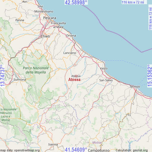
Atessa GPS coordinates[2]
42° 4' 12.648" North, 14° 27' 1.764" East
| Map corner | latitude | longitude |
|---|---|---|
| Upper-left | 42.58998°, | 13.74737° |
| Center: | 42.07018°, | 14.45049° |
| Lower-right: | 41.54609°, | 15.15362° |
| Map W x H: | 116.1×116.1 km | = 72.1×72.1mi |
| max Lat: | 47.04031° ⇑69.7% North |
| Atessa: | 42.07018° |
| min Lat: | ⇓30.3% South 35.50142° |
| min Long | Atessa | max Long |
| 6.69888° | 14.45049° | 18.48682° |
| W 82.2%⇐ | ⇒17.8% E |
Elevation
Elevation of Atessa is 418 m = 1371 ft, and this is 111.3 m = 365 ft above average elevation for this country.
| Max E: |
2085 m = 6841 ft | 27.7% |
| Atessa | 418 m 1371 ft | |
| Avg. | 306.7 m = 1006 ft | |
Min E: |
-4 m = -13 ft | 72.3% |
See also: Italy elevation on elevation.city.
Geographical zone
Atessa is located in North temperate zone (between Tropic of Cancer and the Arctic Circle). Distance of this Northern Tropic circle is 2071.8 km =1287.4 mi to South.| Distance of | km | miles | from Atessa |
|---|---|---|---|
| North Pole | 5329.3 | 3311.5 | to North |
| Arctic Circle | 2723.4 | 1692.2 | to North |
| Tropic Cancer | 2071.8 | 1287.4 | to South |
| Equator | 4677.8 | 2906.6 | to South |


Nearby cities:
15 places around Atessa: (largest is in red/bold)
• Altino
10.3 km =6.4 mi,  288°
288°
• Archi
6.1 km =3.8 mi, 292°
• Bomba
8 km =5 mi,  239°
239°
• Carpineto Sinello
8 km =5 mi,  146°
146°
• Casalanguida
5.2 km =3.2 mi,  133°
133°
• Colledimezzo
10.7 km =6.6 mi,  209°
209°
• Gissi
9.7 km =6 mi, 126°
• Guilmi
8.5 km =5.3 mi,  164°
164°
• Monte Marcone
6.1 km =3.8 mi,  345°
345°
• Perano
5.9 km =3.7 mi,  310°
310°
• Piane d'Archi-Quadroni
7.6 km =4.7 mi,  299°
299°
• Piazzano-Piana la Fara
7.2 km =4.5 mi,  333°
333°
• Quadroni-Fontolfi-Impicciaturo-Maligni
7.5 km =4.7 mi, 305°
• Selva
10.1 km =6.3 mi, 299°
• Tornareccio
4.6 km =2.9 mi,  218°
218°
Sources, notices
• [Note1] Compared only with cities in Italy existing in our database
• [Src1] Map data: © OpenStreetMap contributors (CC-BY-SA)
• [Src2] Other city data from geonames.org with taken over terms of usage.
• [Src3] Geographical zone / Annual Mean Temperature by Robert A. Rohde @ Wikipedia
