Toano geodata
Toano (Emilia-Romagna) is a seat of a third-order administrative division; located in Italy in Europe/Rome (GMT+2) time zone. With population of 695 people, there are 8330 cities with bigger population in this country. Compared to other cities in Italy, 50.9% of cities are located further ↑North; 62.2% of cities are located further →East and 94.5% of cities have lower elevation than Toano. Note1
Administrative division(s):
- Level 1: Emilia-Romagna
- Level 2: Provincia di Reggio Emilia
- Level 3: Toano


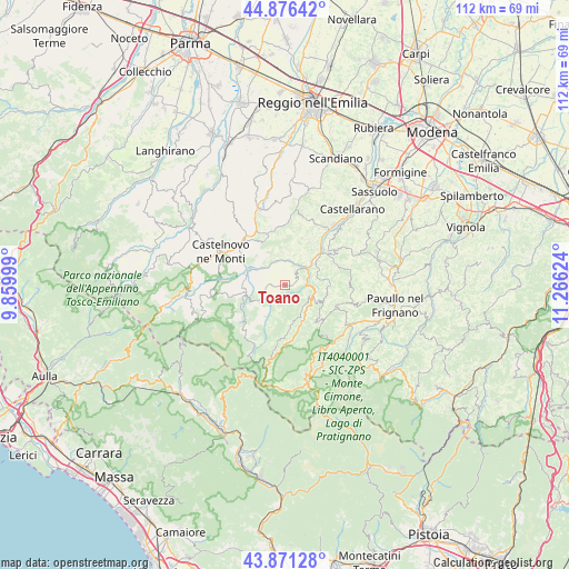
Toano GPS coordinates[2]
44° 22' 33.636" North, 10° 33' 47.196" East
| Map corner | latitude | longitude |
|---|---|---|
| Upper-left | 44.87642°, | 9.85999° |
| Center: | 44.37601°, | 10.56311° |
| Lower-right: | 43.87128°, | 11.26624° |
| Map W x H: | 111.8×111.8 km | = 69.5×69.5mi |
| max Lat: | 47.04031° ⇑50.9% North |
| Toano: | 44.37601° |
| min Lat: | ⇓49.1% South 35.50142° |
| min Long | Toano | max Long |
| 6.69888° | 10.56311° | 18.48682° |
| W 37.8%⇐ | ⇒62.2% E |
Elevation
Elevation of Toano is 855 m = 2805 ft, and this is 548.3 m = 1799 ft above average elevation for this country.
| Max E: |
2085 m = 6841 ft | 5.5% |
| Toano | 855 m 2805 ft | |
| Avg. | 306.7 m = 1006 ft | |
Min E: |
-4 m = -13 ft | 94.5% |
See also: Italy elevation on elevation.city.
Geographical zone
Toano is located in North temperate zone (between Tropic of Cancer and the Arctic Circle). Distance of this Northern Tropic circle is 2328.2 km =1446.7 mi to South.| Distance of | km | miles | from Toano |
|---|---|---|---|
| North Pole | 5072.9 | 3152.2 | to North |
| Arctic Circle | 2467 | 1532.9 | to North |
| Tropic Cancer | 2328.2 | 1446.7 | to South |
| Equator | 4934.1 | 3065.9 | to South |


Nearby cities:
15 places around Toano: (largest is in red/bold)
• Baiso
13.7 km =8.5 mi,  12°
12°
• Carpineti
9.6 km =6 mi,  337°
337°
• Casina
15.7 km =9.8 mi, 341°
• Castelnovo ne'Monti
14.3 km =8.9 mi,  297°
297°
• Cavola
3.7 km =2.3 mi,  317°
317°
• Felina
12 km =7.5 mi, 317°
• Frassinoro
9.1 km =5.7 mi,  175°
175°
• Lama
15.4 km =9.6 mi,  119°
119°
• Montefiorino
5.4 km =3.4 mi, 117°
• Palagano
9 km =5.6 mi,  132°
132°
• Polinago
13.4 km =8.3 mi,  104°
104°
• Prignano
12.3 km =7.6 mi,  55°
55°
• Prignano sulla Secchia
12.4 km =7.7 mi, 55°
• Roteglia
15.6 km =9.7 mi,  39°
39°
• Villa Minozzo
7.9 km =4.9 mi,  260°
260°
Sources, notices
• [Note1] Compared only with cities in Italy existing in our database
• [Src1] Map data: © OpenStreetMap contributors (CC-BY-SA)
• [Src2] Other city data from geonames.org with taken over terms of usage.
• [Src3] Geographical zone / Annual Mean Temperature by Robert A. Rohde @ Wikipedia
