Prignano geodata
Prignano (Emilia-Romagna) is a seat of a third-order administrative division; located in Italy in Europe/Rome (GMT+2) time zone. With population of 604 people, there are 8960 cities with bigger population in this country. Compared to other cities in Italy, 50.1% of cities are located further ↓South; 61% of cities are located further →East and 82.1% of cities have lower elevation than Prignano. Note1
Administrative division(s):
- Level 1: Emilia-Romagna
- Level 2: Provincia di Modena
- Level 3: Prignano sulla Secchia


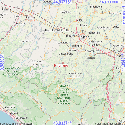
Prignano GPS coordinates[2]
44° 26' 16.44" North, 10° 41' 28.248" East
| Map corner | latitude | longitude |
|---|---|---|
| Upper-left | 44.93778°, | 9.98806° |
| Center: | 44.4379°, | 10.69118° |
| Lower-right: | 43.93371°, | 11.39431° |
| Map W x H: | 111.6×111.6 km | = 69.3×69.3mi |
| max Lat: | 47.04031° ⇑49.9% North |
| Prignano: | 44.4379° |
| min Lat: | ⇓50.1% South 35.50142° |
| min Long | Prignano | max Long |
| 6.69888° | 10.69118° | 18.48682° |
| W 39%⇐ | ⇒61% E |
Elevation
Elevation of Prignano is 556 m = 1824 ft, and this is 249.3 m = 818 ft above average elevation for this country.
| Max E: |
2085 m = 6841 ft | 17.9% |
| Prignano | 556 m 1824 ft | |
| Avg. | 306.7 m = 1006 ft | |
Min E: |
-4 m = -13 ft | 82.1% |
See also: Italy elevation on elevation.city.
Geographical zone
Prignano is located in North temperate zone (between Tropic of Cancer and the Arctic Circle). Distance of this Northern Tropic circle is 2335.1 km =1451 mi to South.| Distance of | km | miles | from Prignano |
|---|---|---|---|
| North Pole | 5066 | 3147.9 | to North |
| Arctic Circle | 2460.1 | 1528.6 | to North |
| Tropic Cancer | 2335.1 | 1451 | to South |
| Equator | 4941 | 3070.2 | to South |


Nearby cities:
15 places around Prignano: (largest is in red/bold)
• Baiso
9.7 km =6 mi,  312°
312°
• Cadiroggio
13 km =8.1 mi,  18°
18°
• Carpineti
13.9 km =8.6 mi,  278°
278°
• Castellarano
9.7 km =6 mi, 22°
• Cavola
13.3 km =8.3 mi,  251°
251°
• Montefiorino
10.8 km =6.7 mi,  209°
209°
• Palagano
13.4 km =8.3 mi,  195°
195°
• Polinago
10.7 km =6.6 mi,  165°
165°
• Prignano sulla Secchia
0.1 km =0.1 mi,  48°
48°
• Roteglia
5.1 km =3.2 mi,  357°
357°
• San Michele dei Mucchietti
9 km =5.6 mi,  29°
29°
• Sassuolo
13.9 km =8.6 mi, 32°
• Serramazzoni
8 km =5 mi,  98°
98°
• Toano
12.3 km =7.6 mi,  235°
235°
• Viano
13.1 km =8.1 mi,  336°
336°
Sources, notices
• [Note1] Compared only with cities in Italy existing in our database
• [Src1] Map data: © OpenStreetMap contributors (CC-BY-SA)
• [Src2] Other city data from geonames.org with taken over terms of usage.
• [Src3] Geographical zone / Annual Mean Temperature by Robert A. Rohde @ Wikipedia
