Palagano geodata
Palagano (Emilia-Romagna) is a seat of a third-order administrative division; located in Italy in Europe/Rome (GMT+2) time zone. With population of 682 people, there are 8413 cities with bigger population in this country. Compared to other cities in Italy, 51.6% of cities are located further ↑North; 61.4% of cities are located further →East and 89.4% of cities have lower elevation than Palagano. Note1


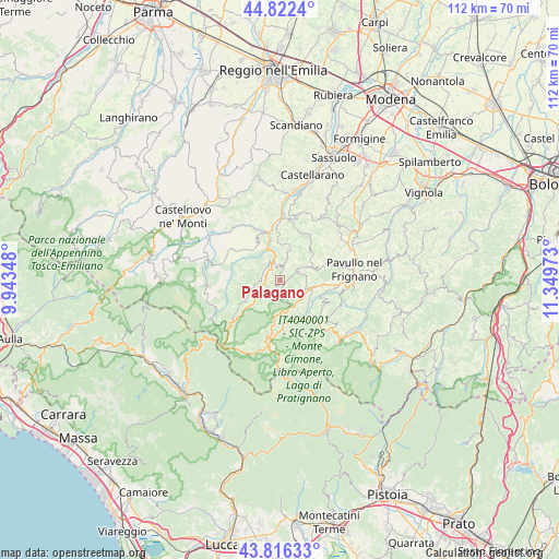
Palagano GPS coordinates[2]
44° 19' 17.472" North, 10° 38' 47.76" East
| Map corner | latitude | longitude |
|---|---|---|
| Upper-left | 44.8224°, | 9.94348° |
| Center: | 44.32152°, | 10.6466° |
| Lower-right: | 43.81633°, | 11.34973° |
| Map W x H: | 111.9×111.9 km | = 69.5×69.5mi |
| max Lat: | 47.04031° ⇑51.6% North |
| Palagano: | 44.32152° |
| min Lat: | ⇓48.4% South 35.50142° |
| min Long | Palagano | max Long |
| 6.69888° | 10.6466° | 18.48682° |
| W 38.6%⇐ | ⇒61.4% E |
Elevation
Elevation of Palagano is 705 m = 2313 ft, and this is 398.3 m = 1307 ft above average elevation for this country.
| Max E: |
2085 m = 6841 ft | 10.6% |
| Palagano | 705 m 2313 ft | |
| Avg. | 306.7 m = 1006 ft | |
Min E: |
-4 m = -13 ft | 89.4% |
See also: Italy elevation on elevation.city.
Geographical zone
Palagano is located in North temperate zone (between Tropic of Cancer and the Arctic Circle). Distance of this Northern Tropic circle is 2322.2 km =1442.9 mi to South.| Distance of | km | miles | from Palagano |
|---|---|---|---|
| North Pole | 5079 | 3155.9 | to North |
| Arctic Circle | 2473.1 | 1536.7 | to North |
| Tropic Cancer | 2322.2 | 1442.9 | to South |
| Equator | 4928.1 | 3062.2 | to South |


Nearby cities:
15 places around Palagano: (largest is in red/bold)
• Cavola
12.6 km =7.8 mi,  313°
313°
• Frassinoro
6.7 km =4.2 mi,  243°
243°
• Lama
6.9 km =4.3 mi,  103°
103°
• Montecreto
10.1 km =6.3 mi,  146°
146°
• Montefiorino
4 km =2.5 mi,  333°
333°
• Pavullo nel Frignano
15.1 km =9.4 mi,  84°
84°
• Pievepelago
13.2 km =8.2 mi,  190°
190°
• Polinago
6.8 km =4.2 mi,  67°
67°
• Prignano
13.4 km =8.3 mi,  15°
15°
• Prignano sulla Secchia
13.5 km =8.4 mi, 15°
• Querciagrossa
14.5 km =9 mi,  94°
94°
• Riolunato
10.1 km =6.3 mi,  177°
177°
• Sestola
14.3 km =8.9 mi,  135°
135°
• Toano
9 km =5.6 mi, 312°
• Villa Minozzo
15.2 km =9.4 mi,  288°
288°
Sources, notices
• [Note1] Compared only with cities in Italy existing in our database
• [Src1] Map data: © OpenStreetMap contributors (CC-BY-SA)
• [Src2] Other city data from geonames.org with taken over terms of usage.
• [Src3] Geographical zone / Annual Mean Temperature by Robert A. Rohde @ Wikipedia
