Tesero geodata
Tesero (Trentino-Alto Adige) is a seat of a third-order administrative division; located in Italy in Europe/Rome (GMT+2) time zone. With population of 2,281 people, there are 3781 cities with bigger population in this country. Compared to other cities in Italy, 96.8% of cities are located further ↓South; 50.5% of cities are located further →East and 97.3% of cities have lower elevation than Tesero. Note1
Administrative division(s):
- Level 1: Trentino-Alto Adige
- Level 2: Provincia autonoma di Trento
- Level 3: Tesero


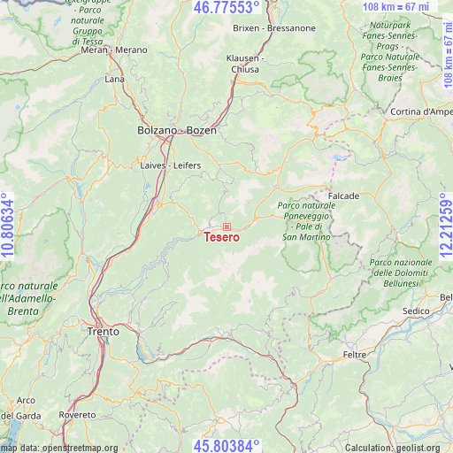
Tesero GPS coordinates[2]
46° 17' 30.624" North, 11° 30' 34.056" East
| Map corner | latitude | longitude |
|---|---|---|
| Upper-left | 46.77553°, | 10.80634° |
| Center: | 46.29184°, | 11.50946° |
| Lower-right: | 45.80384°, | 12.21259° |
| Map W x H: | 108×108 km | = 67.1×67.1mi |
| max Lat: | 47.04031° ⇑3.2% North |
| Tesero: | 46.29184° |
| min Lat: | ⇓96.8% South 35.50142° |
| min Long | Tesero | max Long |
| 6.69888° | 11.50946° | 18.48682° |
| W 49.5%⇐ | ⇒50.5% E |
Elevation
Elevation of Tesero is 1023 m = 3356 ft, and this is 716.3 m = 2350 ft above average elevation for this country.
| Max E: |
2085 m = 6841 ft | 2.7% |
| Tesero | 1023 m 3356 ft | |
| Avg. | 306.7 m = 1006 ft | |
Min E: |
-4 m = -13 ft | 97.3% |
See also: Italy elevation on elevation.city.
Geographical zone
Tesero is located in North temperate zone (between Tropic of Cancer and the Arctic Circle). Distance of this North polar circle is 2254 km =1400.6 mi to North.| Distance of | km | miles | from Tesero |
|---|---|---|---|
| North Pole | 4859.9 | 3019.8 | to North |
| Arctic Circle | 2254 | 1400.6 | to North |
| Tropic Cancer | 2541.3 | 1579.1 | to South |
| Equator | 5147.2 | 3198.3 | to South |


Nearby cities:
15 places around Tesero: (largest is in red/bold)
• Aldino
14.4 km =8.9 mi,  304°
304°
• Anterivo
11.1 km =6.9 mi,  262°
262°
• Capriana
13.6 km =8.5 mi, 256°
• Carano
5.4 km =3.4 mi,  269°
269°
• Castello Molina di Fiemme
5.9 km =3.7 mi, 259°
• Cavalese
3.9 km =2.4 mi, 267°
• Daiano
4.8 km =3 mi,  283°
283°
• Masi di Cavalese
2.2 km =1.4 mi,  240°
240°
• Molina
7.4 km =4.6 mi,  252°
252°
• Panchià
2.5 km =1.6 mi,  103°
103°
• Predazzo
7.3 km =4.5 mi,  72°
72°
• Trodena
12.7 km =7.9 mi,  285°
285°
• Valfloriana
13.6 km =8.5 mi, 249°
• Varena
4.3 km =2.7 mi, 292°
• Ziano di Fiemme
4.3 km =2.7 mi, 99°
Sources, notices
• [Note1] Compared only with cities in Italy existing in our database
• [Src1] Map data: © OpenStreetMap contributors (CC-BY-SA)
• [Src2] Other city data from geonames.org with taken over terms of usage.
• [Src3] Geographical zone / Annual Mean Temperature by Robert A. Rohde @ Wikipedia
