Terzigno geodata
Terzigno (Campania) is a seat of a third-order administrative division; located in Italy in Europe/Rome (GMT+2) time zone. With population of 17,138 people, there are 520 cities with bigger population in this country. Compared to other cities in Italy, 81.3% of cities are located further ↑North; 82.6% of cities are located further ←West and 68.8% of cities have higher elevation than Terzigno. Note1


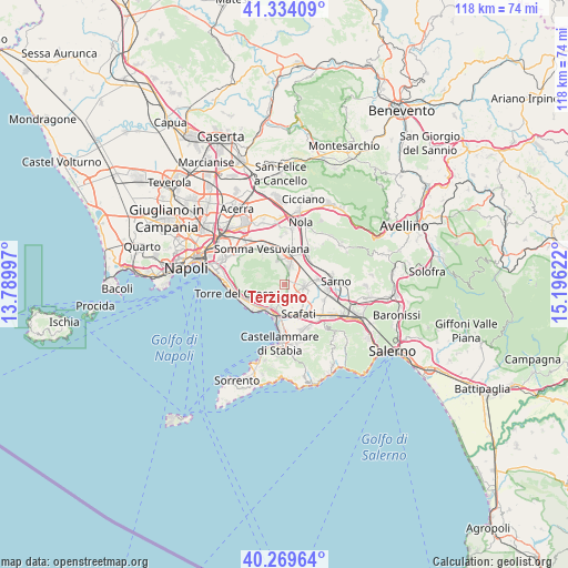
Terzigno GPS coordinates[2]
40° 48' 14.4" North, 14° 29' 35.124" East
| Map corner | latitude | longitude |
|---|---|---|
| Upper-left | 41.33409°, | 13.78997° |
| Center: | 40.804°, | 14.49309° |
| Lower-right: | 40.26964°, | 15.19622° |
| Map W x H: | 118.4×118.4 km | = 73.6×73.6mi |
| max Lat: | 47.04031° ⇑81.3% North |
| Terzigno: | 40.804° |
| min Lat: | ⇓18.7% South 35.50142° |
| min Long | Terzigno | max Long |
| 6.69888° | 14.49309° | 18.48682° |
| W 82.6%⇐ | ⇒17.4% E |
Elevation
Elevation of Terzigno is 104 m = 341 ft, and this is 202.7 m = 665 ft below average elevation for this country.
| Max E: |
2085 m = 6841 ft | 68.8% |
| Avg. | 306.7 m = 1006 ft | |
| Terzigno | 104 m = 341 ft | |
Min E: |
-4 m = -13 ft | 31.2% |
See also: Italy elevation on elevation.city.
Geographical zone
Terzigno is located in North temperate zone (between Tropic of Cancer and the Arctic Circle). Distance of this Northern Tropic circle is 1931.1 km =1199.9 mi to South.| Distance of | km | miles | from Terzigno |
|---|---|---|---|
| North Pole | 5470.1 | 3399 | to North |
| Arctic Circle | 2864.2 | 1779.7 | to North |
| Tropic Cancer | 1931.1 | 1199.9 | to South |
| Equator | 4537 | 2819.2 | to South |


Nearby cities:
15 places around Terzigno: (largest is in red/bold)
• Boscoreale
3.6 km =2.2 mi,  196°
196°
• Boscotrecase
4.3 km =2.7 mi,  217°
217°
• Calvanese
7.9 km =4.9 mi,  165°
165°
• Fornillo
2.7 km =1.7 mi,  102°
102°
• Ottaviano
5.5 km =3.4 mi,  346°
346°
• Piazzola
7.7 km =4.8 mi,  4°
4°
• Poggiomarino
4 km =2.5 mi,  94°
94°
• Pompei
6.5 km =4 mi,  177°
177°
• San Gennaro Vesuviano
7 km =4.3 mi,  21°
21°
• San Giuseppe Vesuviano
3.7 km =2.3 mi, 15°
• San Marzano sul Sarno
7.9 km =4.9 mi,  111°
111°
• Scafati
6.1 km =3.8 mi,  142°
142°
• Striano
7 km =4.3 mi,  79°
79°
• Torre Annunziata
6.6 km =4.1 mi,  211°
211°
• Trecase
6 km =3.7 mi,  230°
230°
Sources, notices
• [Note1] Compared only with cities in Italy existing in our database
• [Src1] Map data: © OpenStreetMap contributors (CC-BY-SA)
• [Src2] Other city data from geonames.org with taken over terms of usage.
• [Src3] Geographical zone / Annual Mean Temperature by Robert A. Rohde @ Wikipedia
