Fornillo geodata
Fornillo (Campania) is a populated place; located in Italy in Europe/Rome (GMT+2) time zone. With population of 857 people, there are 7374 cities with bigger population in this country. Compared to other cities in Italy, 81.4% of cities are located further ↑North; 82.9% of cities are located further ←West and 82.5% of cities have higher elevation than Fornillo. Note1


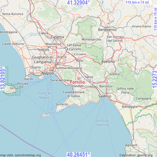
Fornillo GPS coordinates[2]
40° 47' 56.076" North, 14° 31' 27.012" East
| Map corner | latitude | longitude |
|---|---|---|
| Upper-left | 41.32904°, | 13.82105° |
| Center: | 40.79891°, | 14.52417° |
| Lower-right: | 40.26451°, | 15.2273° |
| Map W x H: | 118.4×118.4 km | = 73.6×73.6mi |
| max Lat: | 47.04031° ⇑81.4% North |
| Fornillo: | 40.79891° |
| min Lat: | ⇓18.6% South 35.50142° |
| min Long | Fornillo | max Long |
| 6.69888° | 14.52417° | 18.48682° |
| W 82.9%⇐ | ⇒17.1% E |
Elevation
Elevation of Fornillo is 40 m = 131 ft, and this is 266.7 m = 875 ft below average elevation for this country.
| Max E: |
2085 m = 6841 ft | 82.5% |
| Avg. | 306.7 m = 1006 ft | |
| Fornillo | 40 m = 131 ft | |
Min E: |
-4 m = -13 ft | 17.5% |
See also: Italy elevation on elevation.city.
Geographical zone
Fornillo is located in North temperate zone (between Tropic of Cancer and the Arctic Circle). Distance of this Northern Tropic circle is 1930.5 km =1199.6 mi to South.| Distance of | km | miles | from Fornillo |
|---|---|---|---|
| North Pole | 5470.6 | 3399.3 | to North |
| Arctic Circle | 2864.8 | 1780.1 | to North |
| Tropic Cancer | 1930.5 | 1199.6 | to South |
| Equator | 4536.4 | 2818.8 | to South |


Nearby cities:
15 places around Fornillo: (largest is in red/bold)
• Boscoreale
4.6 km =2.9 mi,  231°
231°
• Boscotrecase
6 km =3.7 mi,  241°
241°
• Calvanese
7.1 km =4.4 mi,  185°
185°
• Ottaviano
7 km =4.3 mi,  326°
326°
• Poggiomarino
1.4 km =0.9 mi,  79°
79°
• Pompei
6.3 km =3.9 mi,  201°
201°
• Ponte San Michele
6.6 km =4.1 mi,  59°
59°
• San Gennaro Vesuviano
7 km =4.3 mi,  359°
359°
• San Giuseppe Vesuviano
4.4 km =2.7 mi,  338°
338°
• San Lorenzo
7.4 km =4.6 mi,  132°
132°
• San Marzano sul Sarno
5.2 km =3.2 mi,  116°
116°
• San Valentino Torio
6.7 km =4.2 mi,  97°
97°
• Scafati
4.4 km =2.7 mi,  165°
165°
• Striano
4.7 km =2.9 mi,  66°
66°
• Terzigno
2.7 km =1.7 mi,  282°
282°
Sources, notices
• [Note1] Compared only with cities in Italy existing in our database
• [Src1] Map data: © OpenStreetMap contributors (CC-BY-SA)
• [Src2] Other city data from geonames.org with taken over terms of usage.
• [Src3] Geographical zone / Annual Mean Temperature by Robert A. Rohde @ Wikipedia
