Telgate geodata
Telgate (Lombardy) is a seat of a third-order administrative division; located in Italy in Europe/Rome (GMT+2) time zone. With population of 4,720 people, there are 2064 cities with bigger population in this country. Compared to other cities in Italy, 78.2% of cities are located further ↓South; 69.4% of cities are located further →East and 56.5% of cities have higher elevation than Telgate. Note1


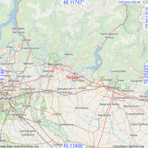
Telgate GPS coordinates[2]
45° 37' 40.512" North, 9° 50' 56.832" East
| Map corner | latitude | longitude |
|---|---|---|
| Upper-left | 46.11747°, | 9.146° |
| Center: | 45.62792°, | 9.84912° |
| Lower-right: | 45.13406°, | 10.55225° |
| Map W x H: | 109.3×109.3 km | = 67.9×67.9mi |
| max Lat: | 47.04031° ⇑21.8% North |
| Telgate: | 45.62792° |
| min Lat: | ⇓78.2% South 35.50142° |
| min Long | Telgate | max Long |
| 6.69888° | 9.84912° | 18.48682° |
| W 30.6%⇐ | ⇒69.4% E |
Elevation
Elevation of Telgate is 191 m = 627 ft, and this is 115.7 m = 380 ft below average elevation for this country.
| Max E: |
2085 m = 6841 ft | 56.5% |
| Avg. | 306.7 m = 1006 ft | |
| Telgate | 191 m = 627 ft | |
Min E: |
-4 m = -13 ft | 43.5% |
See also: Italy elevation on elevation.city.
Geographical zone
Telgate is located in North temperate zone (between Tropic of Cancer and the Arctic Circle). Distance of this North polar circle is 2327.8 km =1446.4 mi to North.| Distance of | km | miles | from Telgate |
|---|---|---|---|
| North Pole | 4933.7 | 3065.7 | to North |
| Arctic Circle | 2327.8 | 1446.4 | to North |
| Tropic Cancer | 2467.4 | 1533.2 | to South |
| Equator | 5073.3 | 3152.4 | to South |


Nearby cities:
15 places around Telgate: (largest is in red/bold)
• Bolgare
2.8 km =1.7 mi,  280°
280°
• Calcinate
4 km =2.5 mi,  257°
257°
• Carobbio
4.3 km =2.7 mi,  340°
340°
• Carobbio degli Angeli
4.4 km =2.7 mi, 339°
• Castelli Calepio
3.3 km =2.1 mi,  120°
120°
• Celatica-Tolari
5.8 km =3.6 mi,  45°
45°
• Chiuduno
2.5 km =1.6 mi,  0°
0°
• Costa di Mezzate
5.7 km =3.5 mi,  312°
312°
• Gandosso
4.6 km =2.9 mi,  41°
41°
• Gorlago
5.5 km =3.4 mi, 338°
• Grumello del Monte
2.2 km =1.4 mi,  67°
67°
• Mornico al Serio
5.1 km =3.2 mi,  217°
217°
• Palazzolo sull'Oglio
4.6 km =2.9 mi,  139°
139°
• Palosco
4.4 km =2.7 mi,  192°
192°
• Tagliuno
4.9 km =3 mi, 70°
Sources, notices
• [Note1] Compared only with cities in Italy existing in our database
• [Src1] Map data: © OpenStreetMap contributors (CC-BY-SA)
• [Src2] Other city data from geonames.org with taken over terms of usage.
• [Src3] Geographical zone / Annual Mean Temperature by Robert A. Rohde @ Wikipedia
