Stroppo geodata
Stroppo (Piedmont) is a seat of a third-order administrative division; located in Italy in Europe/Rome (GMT+2) time zone. With population of 108 people, there are 11412 cities with bigger population in this country. Compared to other cities in Italy, 51.1% of cities are located further ↓South; 99.6% of cities are located further →East and 98.1% of cities have lower elevation than Stroppo. Note1


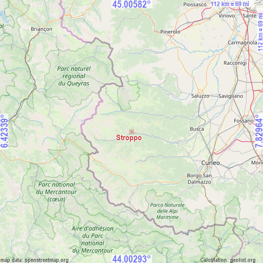
Stroppo GPS coordinates[2]
44° 30' 23.508" North, 7° 7' 35.472" East
| Map corner | latitude | longitude |
|---|---|---|
| Upper-left | 45.00582°, | 6.42339° |
| Center: | 44.50653°, | 7.12652° |
| Lower-right: | 44.00293°, | 7.82964° |
| Map W x H: | 111.5×111.5 km | = 69.3×69.3mi |
| max Lat: | 47.04031° ⇑48.9% North |
| Stroppo: | 44.50653° |
| min Lat: | ⇓51.1% South 35.50142° |
| min Long | Stroppo | max Long |
| 6.69888° | 7.12652° | 18.48682° |
| W 0.4%⇐ | ⇒99.6% E |
Elevation
Elevation of Stroppo is 1100 m = 3609 ft, and this is 793.3 m = 2603 ft above average elevation for this country.
| Max E: |
2085 m = 6841 ft | 1.9% |
| Stroppo | 1100 m 3609 ft | |
| Avg. | 306.7 m = 1006 ft | |
Min E: |
-4 m = -13 ft | 98.1% |
See also: Italy elevation on elevation.city.
Geographical zone
Stroppo is located in North temperate zone (between Tropic of Cancer and the Arctic Circle). Distance of this Northern Tropic circle is 2342.7 km =1455.7 mi to South.| Distance of | km | miles | from Stroppo |
|---|---|---|---|
| North Pole | 5058.4 | 3143.1 | to North |
| Arctic Circle | 2452.5 | 1523.9 | to North |
| Tropic Cancer | 2342.7 | 1455.7 | to South |
| Equator | 4948.7 | 3075 | to South |


Nearby cities:
15 places around Stroppo: (largest is in red/bold)
• Acceglio
11.3 km =7 mi,  251°
251°
• Campomolino
12.8 km =8 mi,  148°
148°
• Canosio
6.6 km =4.1 mi,  211°
211°
• Cartignano
13 km =8.1 mi,  103°
103°
• Casteldelfino
10.3 km =6.4 mi,  334°
334°
• Chiesa di Macra
5 km =3.1 mi,  121°
121°
• Frassino
13.9 km =8.6 mi,  58°
58°
• Macra
4.3 km =2.7 mi, 99°
• Marmora
5.9 km =3.7 mi, 205°
• Pleyne
12 km =7.5 mi,  313°
313°
• Pontechianale
14.9 km =9.3 mi, 329°
• Prazzo Superiore
6.3 km =3.9 mi, 245°
• Sampeyre
9.5 km =5.9 mi,  32°
32°
• San Damiano Macra
10.5 km =6.5 mi, 101°
• Serre
4.7 km =2.9 mi,  322°
322°
Sources, notices
• [Note1] Compared only with cities in Italy existing in our database
• [Src1] Map data: © OpenStreetMap contributors (CC-BY-SA)
• [Src2] Other city data from geonames.org with taken over terms of usage.
• [Src3] Geographical zone / Annual Mean Temperature by Robert A. Rohde @ Wikipedia
