Marmora geodata
Marmora (Piedmont) is a seat of a third-order administrative division; located in Italy in Europe/Rome (GMT+2) time zone. With population of 26 people, there are 11661 cities with bigger population in this country. Compared to other cities in Italy, 50.4% of cities are located further ↓South; 99.6% of cities are located further →East and 98.9% of cities have lower elevation than Marmora. Note1


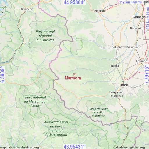
Marmora GPS coordinates[2]
44° 27' 29.988" North, 7° 5' 38.472" East
| Map corner | latitude | longitude |
|---|---|---|
| Upper-left | 44.95804°, | 6.3909° |
| Center: | 44.45833°, | 7.09402° |
| Lower-right: | 43.95431°, | 7.79715° |
| Map W x H: | 111.6×111.6 km | = 69.3×69.3mi |
| max Lat: | 47.04031° ⇑49.6% North |
| Marmora: | 44.45833° |
| min Lat: | ⇓50.4% South 35.50142° |
| min Long | Marmora | max Long |
| 6.69888° | 7.09402° | 18.48682° |
| W 0.4%⇐ | ⇒99.6% E |
Elevation
Elevation of Marmora is 1239 m = 4065 ft, and this is 932.3 m = 3059 ft above average elevation for this country.
| Max E: |
2085 m = 6841 ft | 1.1% |
| Marmora | 1239 m 4065 ft | |
| Avg. | 306.7 m = 1006 ft | |
Min E: |
-4 m = -13 ft | 98.9% |
See also: Italy elevation on elevation.city.
Geographical zone
Marmora is located in North temperate zone (between Tropic of Cancer and the Arctic Circle). Distance of this Northern Tropic circle is 2337.4 km =1452.4 mi to South.| Distance of | km | miles | from Marmora |
|---|---|---|---|
| North Pole | 5063.8 | 3146.5 | to North |
| Arctic Circle | 2457.9 | 1527.3 | to North |
| Tropic Cancer | 2337.4 | 1452.4 | to South |
| Equator | 4943.3 | 3071.6 | to South |


Nearby cities:
15 places around Marmora: (largest is in red/bold)
• Acceglio
8.4 km =5.2 mi,  282°
282°
• Bersezio
13.2 km =8.2 mi,  228°
228°
• Campomolino
10.9 km =6.8 mi,  120°
120°
• Canosio
0.9 km =0.6 mi,  252°
252°
• Casteldelfino
14.8 km =9.2 mi,  352°
352°
• Chiesa di Macra
7.4 km =4.6 mi,  68°
68°
• Macra
8.2 km =5.1 mi,  55°
55°
• Pietraporzio
13.6 km =8.5 mi,  200°
200°
• Pleyne
14.9 km =9.3 mi,  335°
335°
• Prazzo Superiore
4.2 km =2.6 mi,  311°
311°
• Sambuco
13.8 km =8.6 mi,  185°
185°
• Sampeyre
15.4 km =9.6 mi,  29°
29°
• San Damiano Macra
13.3 km =8.3 mi,  75°
75°
• Serre
9.1 km =5.7 mi,  358°
358°
• Stroppo
5.9 km =3.7 mi, 25°
Sources, notices
• [Note1] Compared only with cities in Italy existing in our database
• [Src1] Map data: © OpenStreetMap contributors (CC-BY-SA)
• [Src2] Other city data from geonames.org with taken over terms of usage.
• [Src3] Geographical zone / Annual Mean Temperature by Robert A. Rohde @ Wikipedia
