Serre geodata
Serre (Piedmont) is a seat of a third-order administrative division; located in Italy in Europe/Rome (GMT+2) time zone. With population of 11 people, there are 11696 cities with bigger population in this country. Compared to other cities in Italy, 51.6% of cities are located further ↓South; 99.7% of cities are located further →East and 99.9% of cities have lower elevation than Serre. Note1


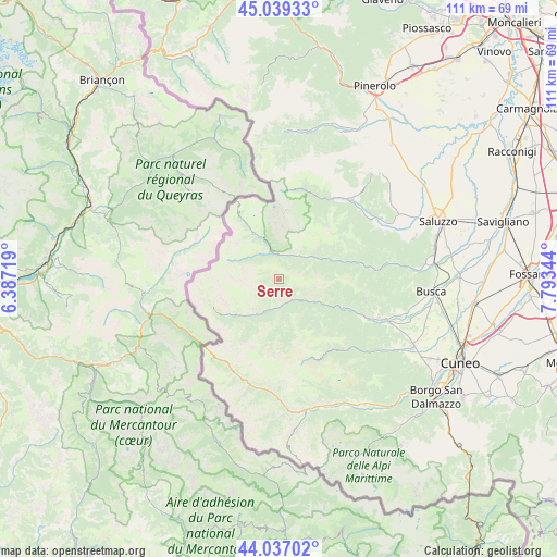
Serre GPS coordinates[2]
44° 32' 25.188" North, 7° 5' 25.152" East
| Map corner | latitude | longitude |
|---|---|---|
| Upper-left | 45.03933°, | 6.38719° |
| Center: | 44.54033°, | 7.09032° |
| Lower-right: | 44.03702°, | 7.79344° |
| Map W x H: | 111.4×111.4 km | = 69.2×69.2mi |
| max Lat: | 47.04031° ⇑48.4% North |
| Serre: | 44.54033° |
| min Lat: | ⇓51.6% South 35.50142° |
| min Long | Serre | max Long |
| 6.69888° | 7.09032° | 18.48682° |
| W 0.3%⇐ | ⇒99.7% E |
Elevation
Elevation of Serre is 1642 m = 5387 ft, and this is 1335.3 m = 4381 ft above average elevation for this country.
| Max E: |
2085 m = 6841 ft | 0.099999999999994% |
| Serre | 1642 m 5387 ft | |
| Avg. | 306.7 m = 1006 ft | |
Min E: |
-4 m = -13 ft | 99.9% |
See also: Italy elevation on elevation.city.
Geographical zone
Serre is located in North temperate zone (between Tropic of Cancer and the Arctic Circle). Distance of this Northern Tropic circle is 2346.5 km =1458 mi to South.| Distance of | km | miles | from Serre |
|---|---|---|---|
| North Pole | 5054.6 | 3140.8 | to North |
| Arctic Circle | 2448.8 | 1521.6 | to North |
| Tropic Cancer | 2346.5 | 1458 | to South |
| Equator | 4952.4 | 3077.3 | to South |


Nearby cities:
15 places around Serre: (largest is in red/bold)
• Acceglio
10.7 km =6.6 mi,  227°
227°
• Canosio
9.4 km =5.8 mi,  183°
183°
• Cartignano
17 km =10.6 mi,  113°
113°
• Casteldelfino
5.7 km =3.5 mi,  343°
343°
• Chiesa di Macra
9.6 km =6 mi,  131°
131°
• Frassino
15.1 km =9.4 mi,  76°
76°
• Macra
8.4 km =5.2 mi,  122°
122°
• Marmora
9.1 km =5.7 mi, 178°
• Oncino
17.1 km =10.6 mi,  27°
27°
• Pleyne
7.3 km =4.5 mi,  307°
307°
• Pontechianale
10.2 km =6.3 mi,  332°
332°
• Prazzo Superiore
7 km =4.3 mi,  203°
203°
• Sampeyre
9 km =5.6 mi,  61°
61°
• San Damiano Macra
14.3 km =8.9 mi, 113°
• Stroppo
4.7 km =2.9 mi,  142°
142°
Sources, notices
• [Note1] Compared only with cities in Italy existing in our database
• [Src1] Map data: © OpenStreetMap contributors (CC-BY-SA)
• [Src2] Other city data from geonames.org with taken over terms of usage.
• [Src3] Geographical zone / Annual Mean Temperature by Robert A. Rohde @ Wikipedia
