Strettoia geodata
Strettoia (Tuscany) is a populated place; located in Italy in Europe/Rome (GMT+2) time zone. With population of 2,722 people, there are 3290 cities with bigger population in this country. Compared to other cities in Italy, 54.8% of cities are located further ↑North; 66% of cities are located further →East and 86.4% of cities have higher elevation than Strettoia. Note1


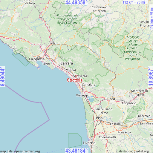
Strettoia GPS coordinates[2]
43° 59' 23.532" North, 10° 11' 36.852" East
| Map corner | latitude | longitude |
|---|---|---|
| Upper-left | 44.49359°, | 9.49044° |
| Center: | 43.98987°, | 10.19357° |
| Lower-right: | 43.48184°, | 10.8967° |
| Map W x H: | 112.5×112.5 km | = 69.9×69.9mi |
| max Lat: | 47.04031° ⇑54.8% North |
| Strettoia: | 43.98987° |
| min Lat: | ⇓45.2% South 35.50142° |
| min Long | Strettoia | max Long |
| 6.69888° | 10.19357° | 18.48682° |
| W 34%⇐ | ⇒66% E |
Elevation
Elevation of Strettoia is 27 m = 89 ft, and this is 279.7 m = 918 ft below average elevation for this country.
| Max E: |
2085 m = 6841 ft | 86.4% |
| Avg. | 306.7 m = 1006 ft | |
| Strettoia | 27 m = 89 ft | |
Min E: |
-4 m = -13 ft | 13.6% |
See also: Italy elevation on elevation.city.
Geographical zone
Strettoia is located in North temperate zone (between Tropic of Cancer and the Arctic Circle). Distance of this Northern Tropic circle is 2285.3 km =1420 mi to South.| Distance of | km | miles | from Strettoia |
|---|---|---|---|
| North Pole | 5115.8 | 3178.8 | to North |
| Arctic Circle | 2510 | 1559.6 | to North |
| Tropic Cancer | 2285.3 | 1420 | to South |
| Equator | 4891.2 | 3039.2 | to South |


Nearby cities:
15 places around Strettoia: (largest is in red/bold)
• Bedizzano
11.3 km =7 mi,  330°
330°
• Camaiore
9.8 km =6.1 mi,  122°
122°
• Capanne-Prato-Cinquale
3.1 km =1.9 mi,  285°
285°
• Casette
9.7 km =6 mi,  347°
347°
• Forno
10.4 km =6.5 mi, 352°
• Forte dei Marmi
3.3 km =2.1 mi,  207°
207°
• Marina di Massa
7.1 km =4.4 mi,  282°
282°
• Massa
6.7 km =4.2 mi,  319°
319°
• Montignoso
4.2 km =2.6 mi,  336°
336°
• Piano di Mommio
11 km =6.8 mi,  144°
144°
• Pietrasanta
4.3 km =2.7 mi, 140°
• Pontestazzemese
8.1 km =5 mi,  84°
84°
• Ripa-Pozzi-Querceta-Ponterosso
1.5 km =0.9 mi,  148°
148°
• San Vito-Cerreto
4.1 km =2.5 mi, 335°
• Seravezza
2.7 km =1.7 mi, 78°
Sources, notices
• [Note1] Compared only with cities in Italy existing in our database
• [Src1] Map data: © OpenStreetMap contributors (CC-BY-SA)
• [Src2] Other city data from geonames.org with taken over terms of usage.
• [Src3] Geographical zone / Annual Mean Temperature by Robert A. Rohde @ Wikipedia
