Seravezza geodata
Seravezza (Tuscany) is a seat of a third-order administrative division; located in Italy in Europe/Rome (GMT+2) time zone. With population of 1,194 people, there are 5978 cities with bigger population in this country. Compared to other cities in Italy, 54.7% of cities are located further ↑North; 65.7% of cities are located further →East and 78.3% of cities have higher elevation than Seravezza. Note1


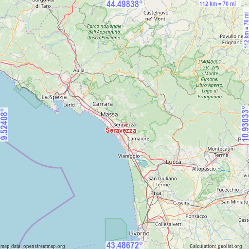
Seravezza GPS coordinates[2]
43° 59' 40.956" North, 10° 13' 37.92" East
| Map corner | latitude | longitude |
|---|---|---|
| Upper-left | 44.49838°, | 9.52408° |
| Center: | 43.99471°, | 10.2272° |
| Lower-right: | 43.48672°, | 10.93033° |
| Map W x H: | 112.5×112.5 km | = 69.9×69.9mi |
| max Lat: | 47.04031° ⇑54.7% North |
| Seravezza: | 43.99471° |
| min Lat: | ⇓45.3% South 35.50142° |
| min Long | Seravezza | max Long |
| 6.69888° | 10.2272° | 18.48682° |
| W 34.3%⇐ | ⇒65.7% E |
Elevation
Elevation of Seravezza is 58 m = 190 ft, and this is 248.7 m = 816 ft below average elevation for this country.
| Max E: |
2085 m = 6841 ft | 78.3% |
| Avg. | 306.7 m = 1006 ft | |
| Seravezza | 58 m = 190 ft | |
Min E: |
-4 m = -13 ft | 21.7% |
See also: Italy elevation on elevation.city.
Geographical zone
Seravezza is located in North temperate zone (between Tropic of Cancer and the Arctic Circle). Distance of this Northern Tropic circle is 2285.8 km =1420.3 mi to South.| Distance of | km | miles | from Seravezza |
|---|---|---|---|
| North Pole | 5115.3 | 3178.5 | to North |
| Arctic Circle | 2509.4 | 1559.3 | to North |
| Tropic Cancer | 2285.8 | 1420.3 | to South |
| Equator | 4891.8 | 3039.6 | to South |


Nearby cities:
15 places around Seravezza: (largest is in red/bold)
• Camaiore
8.1 km =5 mi,  135°
135°
• Capanne-Prato-Cinquale
5.7 km =3.5 mi,  272°
272°
• Casette
10.1 km =6.3 mi,  331°
331°
• Corsanico-Bargecchia
11.5 km =7.1 mi,  146°
146°
• Forno
10.5 km =6.5 mi,  337°
337°
• Forte dei Marmi
5.4 km =3.4 mi,  230°
230°
• Marina di Massa
9.7 km =6 mi,  275°
275°
• Massa
8.4 km =5.2 mi,  302°
302°
• Montignoso
5.5 km =3.4 mi,  306°
306°
• Piano di Mommio
10.2 km =6.3 mi,  158°
158°
• Pietrasanta
3.9 km =2.4 mi,  179°
179°
• Pontestazzemese
5.4 km =3.4 mi,  87°
87°
• Ripa-Pozzi-Querceta-Ponterosso
2.6 km =1.6 mi, 225°
• San Vito-Cerreto
5.4 km =3.4 mi, 305°
• Strettoia
2.7 km =1.7 mi,  258°
258°
Sources, notices
• [Note1] Compared only with cities in Italy existing in our database
• [Src1] Map data: © OpenStreetMap contributors (CC-BY-SA)
• [Src2] Other city data from geonames.org with taken over terms of usage.
• [Src3] Geographical zone / Annual Mean Temperature by Robert A. Rohde @ Wikipedia
