Stradella geodata
Stradella (Lombardy) is a seat of a third-order administrative division; located in Italy in Europe/Rome (GMT+2) time zone. With population of 10,785 people, there are 881 cities with bigger population in this country. Compared to other cities in Italy, 61.9% of cities are located further ↓South; 76.3% of cities are located further →East and 71.5% of cities have higher elevation than Stradella. Note1


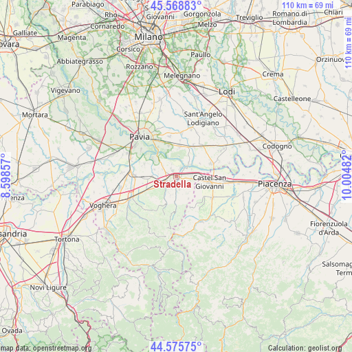
Stradella GPS coordinates[2]
45° 4' 28.02" North, 9° 18' 6.084" East
| Map corner | latitude | longitude |
|---|---|---|
| Upper-left | 45.56883°, | 8.59857° |
| Center: | 45.07445°, | 9.30169° |
| Lower-right: | 44.57575°, | 10.00482° |
| Map W x H: | 110.4×110.4 km | = 68.6×68.6mi |
| max Lat: | 47.04031° ⇑38.1% North |
| Stradella: | 45.07445° |
| min Lat: | ⇓61.9% South 35.50142° |
| min Long | Stradella | max Long |
| 6.69888° | 9.30169° | 18.48682° |
| W 23.7%⇐ | ⇒76.3% E |
Elevation
Elevation of Stradella is 90 m = 295 ft, and this is 216.7 m = 711 ft below average elevation for this country.
| Max E: |
2085 m = 6841 ft | 71.5% |
| Avg. | 306.7 m = 1006 ft | |
| Stradella | 90 m = 295 ft | |
Min E: |
-4 m = -13 ft | 28.5% |
See also: Italy elevation on elevation.city.
Geographical zone
Stradella is located in North temperate zone (between Tropic of Cancer and the Arctic Circle). Distance of this North polar circle is 2389.4 km =1484.7 mi to North.| Distance of | km | miles | from Stradella |
|---|---|---|---|
| North Pole | 4995.3 | 3103.9 | to North |
| Arctic Circle | 2389.4 | 1484.7 | to North |
| Tropic Cancer | 2405.9 | 1495 | to South |
| Equator | 5011.8 | 3114.2 | to South |


Nearby cities:
15 places around Stradella: (largest is in red/bold)
• Albaredo Arnaboldi
5.8 km =3.6 mi,  307°
307°
• Arena Po
5.3 km =3.3 mi,  65°
65°
• Bosnasco
4.5 km =2.8 mi,  104°
104°
• Broni
3.5 km =2.2 mi,  250°
250°
• Campospinoso
4.9 km =3 mi,  296°
296°
• Canneto
3.1 km =1.9 mi,  212°
212°
• Canneto Pavese
3.2 km =2 mi, 214°
• Castana
5.8 km =3.6 mi,  203°
203°
• Montescano
4.9 km =3 mi, 196°
• Montù Beccaria
4.3 km =2.7 mi,  168°
168°
• Portalbera
2.9 km =1.8 mi,  25°
25°
• San Cipriano Po
4.2 km =2.6 mi,  337°
337°
• Spessa
5.7 km =3.5 mi,  40°
40°
• Vallescuropasso-Località Stefano
5.1 km =3.2 mi,  240°
240°
• Zenevredo
3 km =1.9 mi,  139°
139°
Sources, notices
• [Note1] Compared only with cities in Italy existing in our database
• [Src1] Map data: © OpenStreetMap contributors (CC-BY-SA)
• [Src2] Other city data from geonames.org with taken over terms of usage.
• [Src3] Geographical zone / Annual Mean Temperature by Robert A. Rohde @ Wikipedia
