Spessa geodata
Spessa (Lombardy) is a seat of a third-order administrative division; located in Italy in Europe/Rome (GMT+2) time zone. With population of 321 people, there are 10593 cities with bigger population in this country. Compared to other cities in Italy, 62.8% of cities are located further ↓South; 75.5% of cities are located further →East and 77.5% of cities have higher elevation than Spessa. Note1


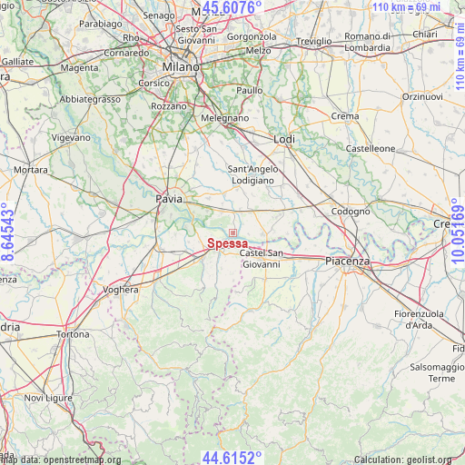
Spessa GPS coordinates[2]
45° 6' 48.816" North, 9° 20' 54.816" East
| Map corner | latitude | longitude |
|---|---|---|
| Upper-left | 45.6076°, | 8.64543° |
| Center: | 45.11356°, | 9.34856° |
| Lower-right: | 44.6152°, | 10.05169° |
| Map W x H: | 110.3×110.3 km | = 68.5×68.5mi |
| max Lat: | 47.04031° ⇑37.2% North |
| Spessa: | 45.11356° |
| min Lat: | ⇓62.8% South 35.50142° |
| min Long | Spessa | max Long |
| 6.69888° | 9.34856° | 18.48682° |
| W 24.5%⇐ | ⇒75.5% E |
Elevation
Elevation of Spessa is 62 m = 203 ft, and this is 244.7 m = 803 ft below average elevation for this country.
| Max E: |
2085 m = 6841 ft | 77.5% |
| Avg. | 306.7 m = 1006 ft | |
| Spessa | 62 m = 203 ft | |
Min E: |
-4 m = -13 ft | 22.5% |
See also: Italy elevation on elevation.city.
Geographical zone
Spessa is located in North temperate zone (between Tropic of Cancer and the Arctic Circle). Distance of this North polar circle is 2385 km =1482 mi to North.| Distance of | km | miles | from Spessa |
|---|---|---|---|
| North Pole | 4990.9 | 3101.2 | to North |
| Arctic Circle | 2385 | 1482 | to North |
| Tropic Cancer | 2410.2 | 1497.6 | to South |
| Equator | 5016.2 | 3116.9 | to South |


Nearby cities:
15 places around Spessa: (largest is in red/bold)
• Arena Po
2.4 km =1.5 mi,  151°
151°
• Belgioioso
5.8 km =3.6 mi,  331°
331°
• Bosnasco
5.5 km =3.4 mi,  173°
173°
• Corteolona
5.3 km =3.3 mi,  20°
20°
• Costa de' Nobili
3.2 km =2 mi,  48°
48°
• Filighera
7.3 km =4.5 mi,  339°
339°
• Pieve Porto Morone
7.2 km =4.5 mi,  93°
93°
• Portalbera
3 km =1.9 mi,  234°
234°
• San Cipriano Po
5.3 km =3.3 mi,  264°
264°
• San Zenone al Po
1.2 km =0.7 mi,  118°
118°
• Santa Cristina
6.3 km =3.9 mi,  39°
39°
• Stradella
5.7 km =3.5 mi,  220°
220°
• Torre de' Negri
4.2 km =2.6 mi, 344°
• Zenevredo
6.9 km =4.3 mi,  194°
194°
• Zerbo
3.7 km =2.3 mi,  95°
95°
Sources, notices
• [Note1] Compared only with cities in Italy existing in our database
• [Src1] Map data: © OpenStreetMap contributors (CC-BY-SA)
• [Src2] Other city data from geonames.org with taken over terms of usage.
• [Src3] Geographical zone / Annual Mean Temperature by Robert A. Rohde @ Wikipedia
