Montescano geodata
Montescano (Lombardy) is a seat of a third-order administrative division; located in Italy in Europe/Rome (GMT+2) time zone. With population of 60 people, there are 11570 cities with bigger population in this country. Compared to other cities in Italy, 60.7% of cities are located further ↓South; 76.6% of cities are located further →East and 55.6% of cities have higher elevation than Montescano. Note1


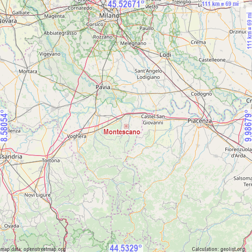
Montescano GPS coordinates[2]
45° 1' 55.056" North, 9° 17' 1.176" East
| Map corner | latitude | longitude |
|---|---|---|
| Upper-left | 45.52671°, | 8.58054° |
| Center: | 45.03196°, | 9.28366° |
| Lower-right: | 44.5329°, | 9.98679° |
| Map W x H: | 110.5×110.5 km | = 68.7×68.7mi |
| max Lat: | 47.04031° ⇑39.3% North |
| Montescano: | 45.03196° |
| min Lat: | ⇓60.7% South 35.50142° |
| min Long | Montescano | max Long |
| 6.69888° | 9.28366° | 18.48682° |
| W 23.4%⇐ | ⇒76.6% E |
Elevation
Elevation of Montescano is 198 m = 650 ft, and this is 108.7 m = 357 ft below average elevation for this country.
| Max E: |
2085 m = 6841 ft | 55.6% |
| Avg. | 306.7 m = 1006 ft | |
| Montescano | 198 m = 650 ft | |
Min E: |
-4 m = -13 ft | 44.4% |
See also: Italy elevation on elevation.city.
Geographical zone
Montescano is located in North temperate zone (between Tropic of Cancer and the Arctic Circle). Distance of this North polar circle is 2394.1 km =1487.6 mi to North.| Distance of | km | miles | from Montescano |
|---|---|---|---|
| North Pole | 5000 | 3106.9 | to North |
| Arctic Circle | 2394.1 | 1487.6 | to North |
| Tropic Cancer | 2401.2 | 1492 | to South |
| Equator | 5007.1 | 3111.3 | to South |


Nearby cities:
15 places around Montescano: (largest is in red/bold)
• Broni
4 km =2.5 mi,  332°
332°
• Canneto
2.1 km =1.3 mi,  354°
354°
• Canneto Pavese
2.1 km =1.3 mi, 349°
• Castana
1.1 km =0.7 mi,  236°
236°
• Cigognola
3.1 km =1.9 mi,  271°
271°
• Lirio
4.7 km =2.9 mi,  207°
207°
• Montù Beccaria
2.3 km =1.4 mi,  77°
77°
• Mornico
6.3 km =3.9 mi,  247°
247°
• Pietra de' Giorgi
4.4 km =2.7 mi, 254°
• Rovescala
5.6 km =3.5 mi,  119°
119°
• San Damiano al Colle
5.1 km =3.2 mi,  96°
96°
• Santa Maria della Versa
5.1 km =3.2 mi,  165°
165°
• Stradella
4.9 km =3 mi,  16°
16°
• Vallescuropasso-Località Stefano
3.8 km =2.4 mi,  305°
305°
• Zenevredo
4.2 km =2.6 mi,  54°
54°
Sources, notices
• [Note1] Compared only with cities in Italy existing in our database
• [Src1] Map data: © OpenStreetMap contributors (CC-BY-SA)
• [Src2] Other city data from geonames.org with taken over terms of usage.
• [Src3] Geographical zone / Annual Mean Temperature by Robert A. Rohde @ Wikipedia
