Vallà geodata
Vallà (Veneto) is a populated place; located in Italy in Europe/Rome (GMT+2) time zone. With population of 2,368 people, there are 3676 cities with bigger population in this country. Compared to other cities in Italy, 81.5% of cities are located further ↓South; 54.9% of cities are located further ←West and 78.8% of cities have higher elevation than Vallà. Note1


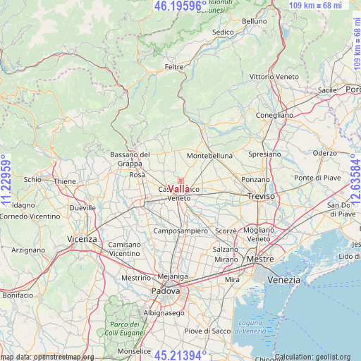
Vallà GPS coordinates[2]
45° 42' 25.596" North, 11° 55' 57.756" East
| Map corner | latitude | longitude |
|---|---|---|
| Upper-left | 46.19596°, | 11.22959° |
| Center: | 45.70711°, | 11.93271° |
| Lower-right: | 45.21394°, | 12.63584° |
| Map W x H: | 109.2×109.2 km | = 67.9×67.9mi |
| max Lat: | 47.04031° ⇑18.5% North |
| Vallà: | 45.70711° |
| min Lat: | ⇓81.5% South 35.50142° |
| min Long | Vallà | max Long |
| 6.69888° | 11.93271° | 18.48682° |
| W 54.9%⇐ | ⇒45.1% E |
Elevation
Elevation of Vallà is 55 m = 180 ft, and this is 251.7 m = 826 ft below average elevation for this country.
| Max E: |
2085 m = 6841 ft | 78.8% |
| Avg. | 306.7 m = 1006 ft | |
| Vallà | 55 m = 180 ft | |
Min E: |
-4 m = -13 ft | 21.2% |
See also: Italy elevation on elevation.city.
Geographical zone
Vallà is located in North temperate zone (between Tropic of Cancer and the Arctic Circle). Distance of this North polar circle is 2319 km =1441 mi to North.| Distance of | km | miles | from Vallà |
|---|---|---|---|
| North Pole | 4924.9 | 3060.2 | to North |
| Arctic Circle | 2319 | 1441 | to North |
| Tropic Cancer | 2476.2 | 1538.6 | to South |
| Equator | 5082.2 | 3157.9 | to South |


Nearby cities:
15 places around Vallà: (largest is in red/bold)
• Altivole
5.5 km =3.4 mi,  19°
19°
• Barcon
6.4 km =4 mi,  75°
75°
• Busta
6.9 km =4.3 mi,  50°
50°
• Caselle
6 km =3.7 mi,  37°
37°
• Castelfranco Veneto
4 km =2.5 mi,  185°
185°
• Castello di Godego
4.4 km =2.7 mi,  248°
248°
• Fanzolo
4.5 km =2.8 mi, 82°
• Loria Bessica
5.8 km =3.6 mi,  295°
295°
• Poggiana
4.2 km =2.6 mi,  288°
288°
• Ramon
5.1 km =3.2 mi,  278°
278°
• Riese Pio X
2.6 km =1.6 mi,  334°
334°
• Salvatronda
5 km =3.1 mi,  136°
136°
• San Vito
5.5 km =3.4 mi,  345°
345°
• Spineda
6.4 km =4 mi,  318°
318°
• Villarazzo
3.7 km =2.3 mi,  216°
216°
Sources, notices
• [Note1] Compared only with cities in Italy existing in our database
• [Src1] Map data: © OpenStreetMap contributors (CC-BY-SA)
• [Src2] Other city data from geonames.org with taken over terms of usage.
• [Src3] Geographical zone / Annual Mean Temperature by Robert A. Rohde @ Wikipedia
