Altivole geodata
Altivole (Veneto) is a seat of a third-order administrative division; located in Italy in Europe/Rome (GMT+2) time zone. With population of 1,369 people, there are 5443 cities with bigger population in this country. Compared to other cities in Italy, 83.7% of cities are located further ↓South; 55.3% of cities are located further ←West and 72% of cities have higher elevation than Altivole. Note1


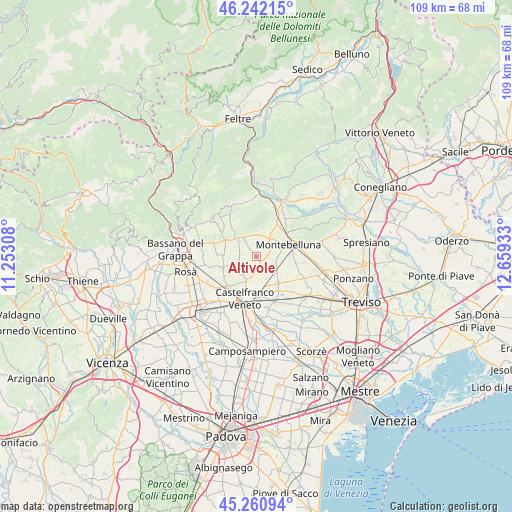
Altivole GPS coordinates[2]
45° 45' 13.32" North, 11° 57' 22.32" East
| Map corner | latitude | longitude |
|---|---|---|
| Upper-left | 46.24215°, | 11.25308° |
| Center: | 45.7537°, | 11.9562° |
| Lower-right: | 45.26094°, | 12.65933° |
| Map W x H: | 109.1×109.1 km | = 67.8×67.8mi |
| max Lat: | 47.04031° ⇑16.3% North |
| Altivole: | 45.7537° |
| min Lat: | ⇓83.7% South 35.50142° |
| min Long | Altivole | max Long |
| 6.69888° | 11.9562° | 18.48682° |
| W 55.3%⇐ | ⇒44.7% E |
Elevation
Elevation of Altivole is 88 m = 289 ft, and this is 218.7 m = 718 ft below average elevation for this country.
| Max E: |
2085 m = 6841 ft | 72% |
| Avg. | 306.7 m = 1006 ft | |
| Altivole | 88 m = 289 ft | |
Min E: |
-4 m = -13 ft | 28% |
See also: Italy elevation on elevation.city.
Geographical zone
Altivole is located in North temperate zone (between Tropic of Cancer and the Arctic Circle). Distance of this North polar circle is 2313.8 km =1437.7 mi to North.| Distance of | km | miles | from Altivole |
|---|---|---|---|
| North Pole | 4919.7 | 3057 | to North |
| Arctic Circle | 2313.8 | 1437.7 | to North |
| Tropic Cancer | 2481.4 | 1541.9 | to South |
| Equator | 5087.3 | 3161.1 | to South |


Nearby cities:
15 places around Altivole: (largest is in red/bold)
• Asolo
4.9 km =3 mi,  321°
321°
• Barcon
5.6 km =3.5 mi,  128°
128°
• Busta
3.6 km =2.2 mi,  103°
103°
• Caerano di San Marco
4.5 km =2.8 mi,  46°
46°
• Caselle
1.9 km =1.2 mi, 103°
• Crespignaga
4.6 km =2.9 mi,  346°
346°
• Fanzolo
5.3 km =3.3 mi,  150°
150°
• Maser
6.1 km =3.8 mi,  13°
13°
• Onè
7.2 km =4.5 mi,  297°
297°
• Poggiana
6.9 km =4.3 mi,  236°
236°
• Riese Pio X
4.1 km =2.5 mi,  226°
226°
• San Vito
3.2 km =2 mi,  272°
272°
• Spineda
6.1 km =3.8 mi, 266°
• Vallà
5.5 km =3.4 mi,  199°
199°
• Villa d'Asolo
4.8 km =3 mi,  294°
294°
Sources, notices
• [Note1] Compared only with cities in Italy existing in our database
• [Src1] Map data: © OpenStreetMap contributors (CC-BY-SA)
• [Src2] Other city data from geonames.org with taken over terms of usage.
• [Src3] Geographical zone / Annual Mean Temperature by Robert A. Rohde @ Wikipedia
