Spilamberto geodata
Spilamberto (Emilia-Romagna) is a seat of a third-order administrative division; located in Italy in Europe/Rome (GMT+2) time zone. With population of 8,770 people, there are 1088 cities with bigger population in this country. Compared to other cities in Italy, 51.5% of cities are located further ↓South; 57.1% of cities are located further →East and 76.1% of cities have higher elevation than Spilamberto. Note1
Administrative division(s):
- Level 1: Emilia-Romagna
- Level 2: Provincia di Modena
- Level 3: Spilamberto


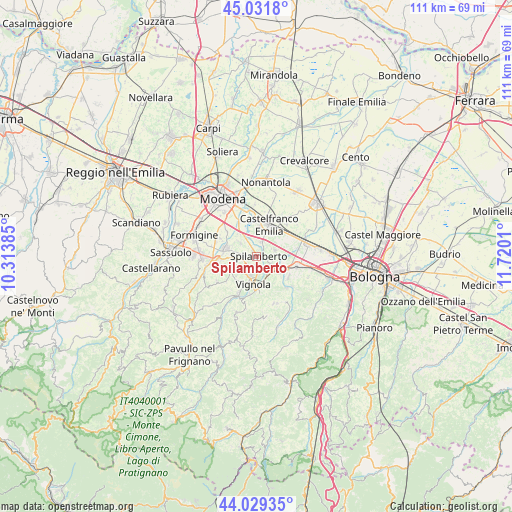
Spilamberto GPS coordinates[2]
44° 31' 57.828" North, 11° 1' 1.092" East
| Map corner | latitude | longitude |
|---|---|---|
| Upper-left | 45.0318°, | 10.31385° |
| Center: | 44.53273°, | 11.01697° |
| Lower-right: | 44.02935°, | 11.7201° |
| Map W x H: | 111.5×111.5 km | = 69.3×69.3mi |
| max Lat: | 47.04031° ⇑48.5% North |
| Spilamberto: | 44.53273° |
| min Lat: | ⇓51.5% South 35.50142° |
| min Long | Spilamberto | max Long |
| 6.69888° | 11.01697° | 18.48682° |
| W 42.9%⇐ | ⇒57.1% E |
Elevation
Elevation of Spilamberto is 69 m = 226 ft, and this is 237.7 m = 780 ft below average elevation for this country.
| Max E: |
2085 m = 6841 ft | 76.1% |
| Avg. | 306.7 m = 1006 ft | |
| Spilamberto | 69 m = 226 ft | |
Min E: |
-4 m = -13 ft | 23.9% |
See also: Italy elevation on elevation.city.
Geographical zone
Spilamberto is located in North temperate zone (between Tropic of Cancer and the Arctic Circle). Distance of this Northern Tropic circle is 2345.7 km =1457.5 mi to South.| Distance of | km | miles | from Spilamberto |
|---|---|---|---|
| North Pole | 5055.5 | 3141.3 | to North |
| Arctic Circle | 2449.6 | 1522.1 | to North |
| Tropic Cancer | 2345.7 | 1457.5 | to South |
| Equator | 4951.6 | 3076.8 | to South |


Nearby cities:
15 places around Spilamberto: (largest is in red/bold)
• Bazzano
6.5 km =4 mi,  121°
121°
• Ca' di Sola
5 km =3.1 mi,  266°
266°
• Castelfranco Emilia
7.3 km =4.5 mi,  20°
20°
• Castelnuovo Rangone
6.9 km =4.3 mi,  285°
285°
• Castelvetro di Modena
6.4 km =4 mi,  240°
240°
• Formica
7.2 km =4.5 mi,  182°
182°
• Mulino
5 km =3.1 mi,  152°
152°
• Piumazzo
4.3 km =2.7 mi,  69°
69°
• San Cesario sul Panaro
3.7 km =2.3 mi, 22°
• San Donnino
6.9 km =4.3 mi,  324°
324°
• San Vito
4.4 km =2.7 mi,  309°
309°
• Sant'Anna
7.4 km =4.6 mi,  0°
0°
• Savignano sul Panaro
6 km =3.7 mi,  166°
166°
• Solignano Nuovo
7.2 km =4.5 mi, 265°
• Vignola
5.5 km =3.4 mi,  185°
185°
Sources, notices
• [Note1] Compared only with cities in Italy existing in our database
• [Src1] Map data: © OpenStreetMap contributors (CC-BY-SA)
• [Src2] Other city data from geonames.org with taken over terms of usage.
• [Src3] Geographical zone / Annual Mean Temperature by Robert A. Rohde @ Wikipedia
