Bazzano geodata
Bazzano (Emilia-Romagna) is a seat of a third-order administrative division; located in Italy in Europe/Rome (GMT+2) time zone. With population of 6,131 people, there are 1608 cities with bigger population in this country. Compared to other cities in Italy, 51% of cities are located further ↓South; 56.1% of cities are located further →East and 72% of cities have higher elevation than Bazzano. Note1


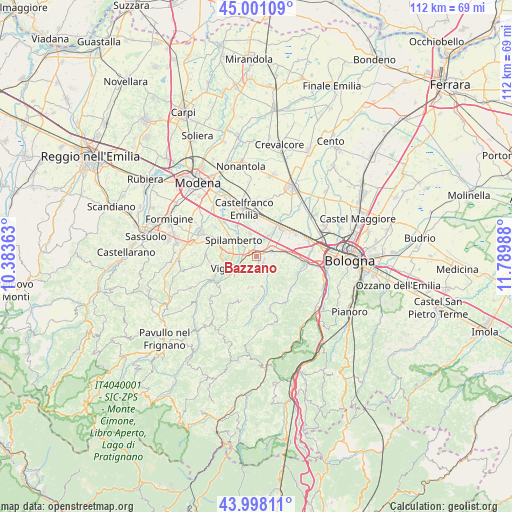
Bazzano GPS coordinates[2]
44° 30' 6.336" North, 11° 5' 12.3" East
| Map corner | latitude | longitude |
|---|---|---|
| Upper-left | 45.00109°, | 10.38363° |
| Center: | 44.50176°, | 11.08675° |
| Lower-right: | 43.99811°, | 11.78988° |
| Map W x H: | 111.5×111.5 km | = 69.3×69.3mi |
| max Lat: | 47.04031° ⇑49% North |
| Bazzano: | 44.50176° |
| min Lat: | ⇓51% South 35.50142° |
| min Long | Bazzano | max Long |
| 6.69888° | 11.08675° | 18.48682° |
| W 43.9%⇐ | ⇒56.1% E |
Elevation
Elevation of Bazzano is 88 m = 289 ft, and this is 218.7 m = 718 ft below average elevation for this country.
| Max E: |
2085 m = 6841 ft | 72% |
| Avg. | 306.7 m = 1006 ft | |
| Bazzano | 88 m = 289 ft | |
Min E: |
-4 m = -13 ft | 28% |
See also: Italy elevation on elevation.city.
Geographical zone
Bazzano is located in North temperate zone (between Tropic of Cancer and the Arctic Circle). Distance of this Northern Tropic circle is 2342.2 km =1455.4 mi to South.| Distance of | km | miles | from Bazzano |
|---|---|---|---|
| North Pole | 5058.9 | 3143.5 | to North |
| Arctic Circle | 2453 | 1524.2 | to North |
| Tropic Cancer | 2342.2 | 1455.4 | to South |
| Equator | 4948.1 | 3074.6 | to South |


Nearby cities:
15 places around Bazzano: (largest is in red/bold)
• Calcara
6.3 km =3.9 mi,  36°
36°
• Calderino
10.2 km =6.3 mi,  118°
118°
• Castelletto
7.1 km =4.4 mi,  194°
194°
• Cavazzona
8.4 km =5.2 mi,  17°
17°
• Crespellano
3.8 km =2.4 mi,  72°
72°
• Formica
6.9 km =4.3 mi,  237°
237°
• Garofano
8.3 km =5.2 mi, 235°
• Mulino
3.3 km =2.1 mi,  252°
252°
• Piumazzo
5.2 km =3.2 mi,  342°
342°
• Ponte Ronca
8.2 km =5.1 mi,  90°
90°
• San Cesario sul Panaro
8 km =5 mi,  329°
329°
• Savignano sul Panaro
4.7 km =2.9 mi, 239°
• Spilamberto
6.5 km =4 mi,  301°
301°
• Stiore
4 km =2.5 mi,  142°
142°
• Vignola
6.3 km =3.9 mi, 251°
Sources, notices
• [Note1] Compared only with cities in Italy existing in our database
• [Src1] Map data: © OpenStreetMap contributors (CC-BY-SA)
• [Src2] Other city data from geonames.org with taken over terms of usage.
• [Src3] Geographical zone / Annual Mean Temperature by Robert A. Rohde @ Wikipedia
