Piumazzo geodata
Piumazzo (Emilia-Romagna) is a populated place; located in Italy in Europe/Rome (GMT+2) time zone. With population of 3,940 people, there are 2425 cities with bigger population in this country. Compared to other cities in Italy, 51.7% of cities are located further ↓South; 56.4% of cities are located further →East and 78.3% of cities have higher elevation than Piumazzo. Note1
Administrative division(s):
- Level 1: Emilia-Romagna
- Level 2: Provincia di Modena
- Level 3: Castelfranco Emilia


Piumazzo GPS coordinates[2]
44° 32' 46.716" North, 11° 4' 2.172" East
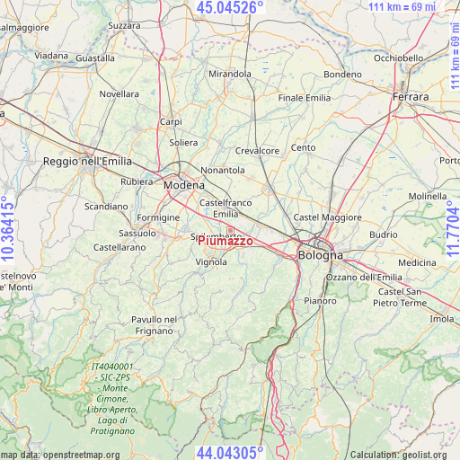
| Map corner | latitude | longitude |
|---|---|---|
| Upper-left | 45.04526°, | 10.36415° |
| Center: | 44.54631°, | 11.06727° |
| Lower-right: | 44.04305°, | 11.7704° |
| Map W x H: | 111.4×111.4 km | = 69.2×69.2mi |
| max Lat: | 47.04031° ⇑48.3% North |
| Piumazzo: | 44.54631° |
| min Lat: | ⇓51.7% South 35.50142° |
| min Long | Piumazzo | max Long |
| 6.69888° | 11.06727° | 18.48682° |
| W 43.6%⇐ | ⇒56.4% E |
Elevation
Elevation of Piumazzo is 58 m = 190 ft, and this is 248.7 m = 816 ft below average elevation for this country.
| Max E: |
2085 m = 6841 ft | 78.3% |
| Avg. | 306.7 m = 1006 ft | |
| Piumazzo | 58 m = 190 ft | |
Min E: |
-4 m = -13 ft | 21.7% |
See also: Italy elevation on elevation.city.
Geographical zone
Piumazzo is located in North temperate zone (between Tropic of Cancer and the Arctic Circle). Distance of this Northern Tropic circle is 2347.2 km =1458.5 mi to South.| Distance of | km | miles | from Piumazzo |
|---|---|---|---|
| North Pole | 5054 | 3140.4 | to North |
| Arctic Circle | 2448.1 | 1521.2 | to North |
| Tropic Cancer | 2347.2 | 1458.5 | to South |
| Equator | 4953.1 | 3077.7 | to South |


Nearby cities:
15 places around Piumazzo: (largest is in red/bold)
• Bazzano
5.2 km =3.2 mi,  162°
162°
• Calcara
5.3 km =3.3 mi,  89°
89°
• Castelfranco Emilia
5.5 km =3.4 mi,  345°
345°
• Cavazzona
5.1 km =3.2 mi,  53°
53°
• Crespellano
6.4 km =4 mi,  126°
126°
• Manzolino
6.1 km =3.8 mi,  25°
25°
• Mulino
6.2 km =3.9 mi,  195°
195°
• San Cesario sul Panaro
3.2 km =2 mi,  306°
306°
• San Donnino
9 km =5.6 mi,  297°
297°
• San Vito
7.5 km =4.7 mi,  280°
280°
• Sant'Anna
7.1 km =4.4 mi,  325°
325°
• Savignano sul Panaro
7.8 km =4.8 mi, 199°
• Spilamberto
4.3 km =2.7 mi,  249°
249°
• Stiore
9 km =5.6 mi,  153°
153°
• Vignola
8.3 km =5.2 mi,  212°
212°
Sources, notices
• [Note1] Compared only with cities in Italy existing in our database
• [Src1] Map data: © OpenStreetMap contributors (CC-BY-SA)
• [Src2] Other city data from geonames.org with taken over terms of usage.
• [Src3] Geographical zone / Annual Mean Temperature by Robert A. Rohde @ Wikipedia
