Sperlonga geodata
Sperlonga (Latium) is a seat of a third-order administrative division; located in Italy in Europe/Rome (GMT+2) time zone. With population of 3,008 people, there are 3035 cities with bigger population in this country. Compared to other cities in Italy, 76.4% of cities are located further ↑North; 72.8% of cities are located further ←West and 94.1% of cities have higher elevation than Sperlonga. Note1


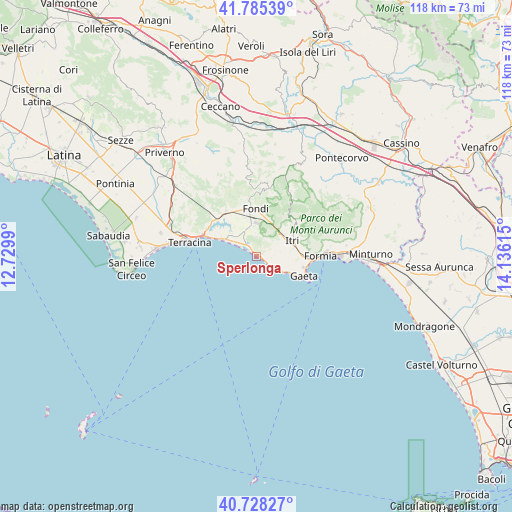
Sperlonga GPS coordinates[2]
41° 15' 32.292" North, 13° 25' 58.872" East
| Map corner | latitude | longitude |
|---|---|---|
| Upper-left | 41.78539°, | 12.7299° |
| Center: | 41.25897°, | 13.43302° |
| Lower-right: | 40.72827°, | 14.13615° |
| Map W x H: | 117.5×117.5 km | = 73×73mi |
| max Lat: | 47.04031° ⇑76.4% North |
| Sperlonga: | 41.25897° |
| min Lat: | ⇓23.6% South 35.50142° |
| min Long | Sperlonga | max Long |
| 6.69888° | 13.43302° | 18.48682° |
| W 72.8%⇐ | ⇒27.2% E |
Elevation
Elevation of Sperlonga is 10 m = 33 ft, and this is 296.7 m = 973 ft below average elevation for this country.
| Max E: |
2085 m = 6841 ft | 94.1% |
| Avg. | 306.7 m = 1006 ft | |
| Sperlonga | 10 m = 33 ft | |
Min E: |
-4 m = -13 ft | 5.9% |
See also: Italy elevation on elevation.city.
Geographical zone
Sperlonga is located in North temperate zone (between Tropic of Cancer and the Arctic Circle). Distance of this Northern Tropic circle is 1981.6 km =1231.3 mi to South.| Distance of | km | miles | from Sperlonga |
|---|---|---|---|
| North Pole | 5419.5 | 3367.5 | to North |
| Arctic Circle | 2813.6 | 1748.3 | to North |
| Tropic Cancer | 1981.6 | 1231.3 | to South |
| Equator | 4587.6 | 2850.6 | to South |


Nearby cities:
15 places around Sperlonga: (largest is in red/bold)
• Borgo Hermada
22.4 km =13.9 mi,  283°
283°
• Campodimele
16.5 km =10.3 mi,  29°
29°
• Fondi
11 km =6.8 mi,  357°
357°
• Formia
14.7 km =9.1 mi,  91°
91°
• Gaeta
12.6 km =7.8 mi,  113°
113°
• Itri
8.8 km =5.5 mi,  66°
66°
• La Fiora
21.6 km =13.4 mi,  292°
292°
• Lenola
16.4 km =10.2 mi,  7°
7°
• Maranola-Trivio
16.5 km =10.3 mi,  79°
79°
• Monte San Biagio
12.5 km =7.8 mi,  327°
327°
• Penitro
21.8 km =13.5 mi, 85°
• Sonnino
23.5 km =14.6 mi,  318°
318°
• Terracina
16.2 km =10.1 mi, 282°
• Valle Bernardo
14.5 km =9 mi,  2°
2°
• Vallecorsa
20.6 km =12.8 mi,  353°
353°
Sources, notices
• [Note1] Compared only with cities in Italy existing in our database
• [Src1] Map data: © OpenStreetMap contributors (CC-BY-SA)
• [Src2] Other city data from geonames.org with taken over terms of usage.
• [Src3] Geographical zone / Annual Mean Temperature by Robert A. Rohde @ Wikipedia
