Gaeta geodata
Gaeta (Latium) is a seat of a third-order administrative division; located in Italy in Europe/Rome (GMT+2) time zone. With population of 19,936 people, there are 444 cities with bigger population in this country. Compared to other cities in Italy, 76.8% of cities are located further ↑North; 74.4% of cities are located further ←West and 94.8% of cities have higher elevation than Gaeta. Note1


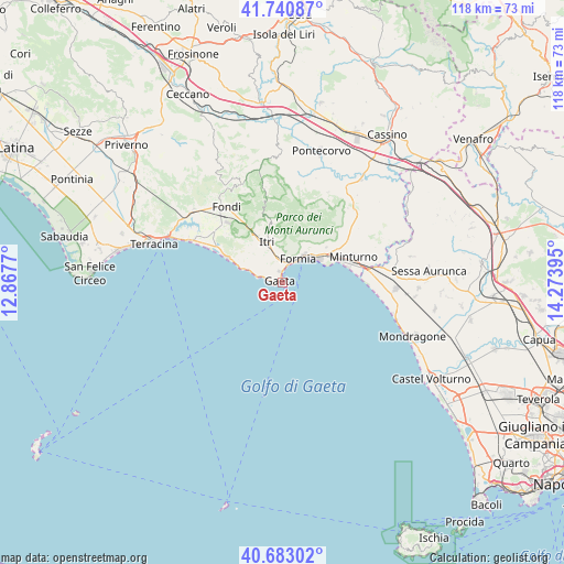
Gaeta GPS coordinates[2]
41° 12' 50.688" North, 13° 34' 14.952" East
| Map corner | latitude | longitude |
|---|---|---|
| Upper-left | 41.74087°, | 12.8677° |
| Center: | 41.21408°, | 13.57082° |
| Lower-right: | 40.68302°, | 14.27395° |
| Map W x H: | 117.6×117.6 km | = 73.1×73.1mi |
| max Lat: | 47.04031° ⇑76.8% North |
| Gaeta: | 41.21408° |
| min Lat: | ⇓23.2% South 35.50142° |
| min Long | Gaeta | max Long |
| 6.69888° | 13.57082° | 18.48682° |
| W 74.4%⇐ | ⇒25.6% E |
Elevation
Elevation of Gaeta is 9 m = 30 ft, and this is 297.7 m = 977 ft below average elevation for this country.
| Max E: |
2085 m = 6841 ft | 94.8% |
| Avg. | 306.7 m = 1006 ft | |
| Gaeta | 9 m = 30 ft | |
Min E: |
-4 m = -13 ft | 5.2% |
See also: Italy elevation on elevation.city.
Geographical zone
Gaeta is located in North temperate zone (between Tropic of Cancer and the Arctic Circle). Distance of this Northern Tropic circle is 1976.7 km =1228.3 mi to South.| Distance of | km | miles | from Gaeta |
|---|---|---|---|
| North Pole | 5424.5 | 3370.6 | to North |
| Arctic Circle | 2818.6 | 1751.4 | to North |
| Tropic Cancer | 1976.7 | 1228.3 | to South |
| Equator | 4582.6 | 2847.5 | to South |


Nearby cities:
15 places around Gaeta: (largest is in red/bold)
• Campodimele
19.6 km =12.2 mi,  350°
350°
• Cerri Aprano
19.3 km =12 mi,  64°
64°
• Fondi
20 km =12.4 mi,  323°
323°
• Formia
5.7 km =3.5 mi,  34°
34°
• Grunuovo-Campomaggiore San Luca
20.8 km =12.9 mi,  71°
71°
• Itri
9.1 km =5.7 mi,  338°
338°
• Maranola-Trivio
9.2 km =5.7 mi, 31°
• Minturno
15.6 km =9.7 mi, 69°
• Penitro
12.1 km =7.5 mi, 57°
• Santa Maria Infante
16.5 km =10.3 mi, 59°
• Sperlonga
12.6 km =7.8 mi,  293°
293°
• Spigno Saturnia Inferiore
17.6 km =10.9 mi,  52°
52°
• Spigno Saturnia Superiore
16 km =9.9 mi, 46°
• Tufo
17.2 km =10.7 mi, 70°
• Ventosa
20.9 km =13 mi,  76°
76°
Sources, notices
• [Note1] Compared only with cities in Italy existing in our database
• [Src1] Map data: © OpenStreetMap contributors (CC-BY-SA)
• [Src2] Other city data from geonames.org with taken over terms of usage.
• [Src3] Geographical zone / Annual Mean Temperature by Robert A. Rohde @ Wikipedia
