Itri geodata
Itri (Latium) is a seat of a third-order administrative division; located in Italy in Europe/Rome (GMT+2) time zone. With population of 8,360 people, there are 1153 cities with bigger population in this country. Compared to other cities in Italy, 76.2% of cities are located further ↑North; 73.9% of cities are located further ←West and 58.7% of cities have higher elevation than Itri. Note1


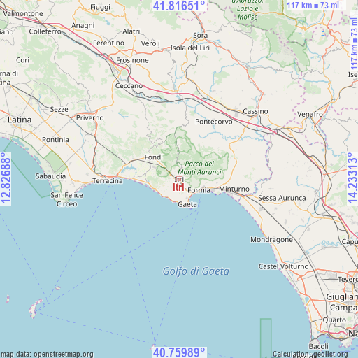
Itri GPS coordinates[2]
41° 17' 25.224" North, 13° 31' 48" East
| Map corner | latitude | longitude |
|---|---|---|
| Upper-left | 41.81651°, | 12.82688° |
| Center: | 41.29034°, | 13.53° |
| Lower-right: | 40.75989°, | 14.23313° |
| Map W x H: | 117.5×117.5 km | = 73×73mi |
| max Lat: | 47.04031° ⇑76.2% North |
| Itri: | 41.29034° |
| min Lat: | ⇓23.8% South 35.50142° |
| min Long | Itri | max Long |
| 6.69888° | 13.53° | 18.48682° |
| W 73.9%⇐ | ⇒26.1% E |
Elevation
Elevation of Itri is 174 m = 571 ft, and this is 132.7 m = 435 ft below average elevation for this country.
| Max E: |
2085 m = 6841 ft | 58.7% |
| Avg. | 306.7 m = 1006 ft | |
| Itri | 174 m = 571 ft | |
Min E: |
-4 m = -13 ft | 41.3% |
See also: Italy elevation on elevation.city.
Geographical zone
Itri is located in North temperate zone (between Tropic of Cancer and the Arctic Circle). Distance of this Northern Tropic circle is 1985.1 km =1233.5 mi to South.| Distance of | km | miles | from Itri |
|---|---|---|---|
| North Pole | 5416 | 3365.3 | to North |
| Arctic Circle | 2810.1 | 1746.1 | to North |
| Tropic Cancer | 1985.1 | 1233.5 | to South |
| Equator | 4591.1 | 2852.8 | to South |


Nearby cities:
15 places around Itri: (largest is in red/bold)
• Campodimele
10.9 km =6.8 mi,  0°
0°
• Esperia
16.5 km =10.3 mi,  51°
51°
• Fondi
11.4 km =7.1 mi,  311°
311°
• Formia
7.6 km =4.7 mi,  119°
119°
• Gaeta
9.1 km =5.7 mi,  158°
158°
• Lenola
14 km =8.7 mi,  335°
335°
• Maranola-Trivio
8.2 km =5.1 mi,  93°
93°
• Monte San Biagio
16.5 km =10.3 mi,  295°
295°
• Monticelli
16.7 km =10.4 mi,  36°
36°
• Penitro
13.7 km =8.5 mi,  97°
97°
• Santa Maria Infante
17.6 km =10.9 mi, 90°
• Sperlonga
8.8 km =5.5 mi,  246°
246°
• Spigno Saturnia Inferiore
17.4 km =10.8 mi,  82°
82°
• Spigno Saturnia Superiore
15.2 km =9.4 mi, 79°
• Valle Bernardo
13.3 km =8.3 mi,  325°
325°
Sources, notices
• [Note1] Compared only with cities in Italy existing in our database
• [Src1] Map data: © OpenStreetMap contributors (CC-BY-SA)
• [Src2] Other city data from geonames.org with taken over terms of usage.
• [Src3] Geographical zone / Annual Mean Temperature by Robert A. Rohde @ Wikipedia
