Sorisole geodata
Sorisole (Lombardy) is a seat of a third-order administrative division; located in Italy in Europe/Rome (GMT+2) time zone. With population of 8,614 people, there are 1107 cities with bigger population in this country. Compared to other cities in Italy, 82.7% of cities are located further ↓South; 71.5% of cities are located further →East and 59.8% of cities have lower elevation than Sorisole. Note1


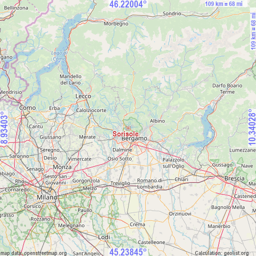
Sorisole GPS coordinates[2]
45° 43' 53.04" North, 9° 38' 13.74" East
| Map corner | latitude | longitude |
|---|---|---|
| Upper-left | 46.22004°, | 8.93403° |
| Center: | 45.7314°, | 9.63715° |
| Lower-right: | 45.23845°, | 10.34028° |
| Map W x H: | 109.1×109.1 km | = 67.8×67.8mi |
| max Lat: | 47.04031° ⇑17.3% North |
| Sorisole: | 45.7314° |
| min Lat: | ⇓82.7% South 35.50142° |
| min Long | Sorisole | max Long |
| 6.69888° | 9.63715° | 18.48682° |
| W 28.5%⇐ | ⇒71.5% E |
Elevation
Elevation of Sorisole is 298 m = 978 ft, and this is 8.7 m = 29 ft below average elevation for this country.
| Max E: |
2085 m = 6841 ft | 40.2% |
| Avg. | 306.7 m = 1006 ft | |
| Sorisole | 298 m = 978 ft | |
Min E: |
-4 m = -13 ft | 59.8% |
See also: Italy elevation on elevation.city.
Geographical zone
Sorisole is located in North temperate zone (between Tropic of Cancer and the Arctic Circle). Distance of this North polar circle is 2316.3 km =1439.3 mi to North.| Distance of | km | miles | from Sorisole |
|---|---|---|---|
| North Pole | 4922.2 | 3058.5 | to North |
| Arctic Circle | 2316.3 | 1439.3 | to North |
| Tropic Cancer | 2478.9 | 1540.3 | to South |
| Equator | 5084.9 | 3159.6 | to South |


Nearby cities:
15 places around Sorisole: (largest is in red/bold)
• Almenno San Bartolomeo
4.5 km =2.8 mi,  281°
281°
• Almenno San Salvatore
3.7 km =2.3 mi,  303°
303°
• Almè
1.9 km =1.2 mi, 296°
• Barzana
5.3 km =3.3 mi,  272°
272°
• Bergamo
4.6 km =2.9 mi,  149°
149°
• Botta
4.4 km =2.7 mi,  336°
336°
• Brembate di Sopra
4.8 km =3 mi,  249°
249°
• Curno
5.2 km =3.2 mi,  204°
204°
• Mozzo
4.3 km =2.7 mi,  211°
211°
• Paladina
2.4 km =1.5 mi, 268°
• Ponte San Pietro
4.6 km =2.9 mi,  232°
232°
• Ponteranica
1.1 km =0.7 mi,  83°
83°
• Scano al Brembo
2.6 km =1.6 mi,  236°
236°
• Sedrina
5.6 km =3.5 mi,  349°
349°
• Villa d'Almè
2.5 km =1.6 mi,  320°
320°
Sources, notices
• [Note1] Compared only with cities in Italy existing in our database
• [Src1] Map data: © OpenStreetMap contributors (CC-BY-SA)
• [Src2] Other city data from geonames.org with taken over terms of usage.
• [Src3] Geographical zone / Annual Mean Temperature by Robert A. Rohde @ Wikipedia
