Sedrina geodata
Sedrina (Lombardy) is a seat of a third-order administrative division; located in Italy in Europe/Rome (GMT+2) time zone. With population of 1,276 people, there are 5710 cities with bigger population in this country. Compared to other cities in Italy, 84.9% of cities are located further ↓South; 71.6% of cities are located further →East and 64.2% of cities have lower elevation than Sedrina. Note1


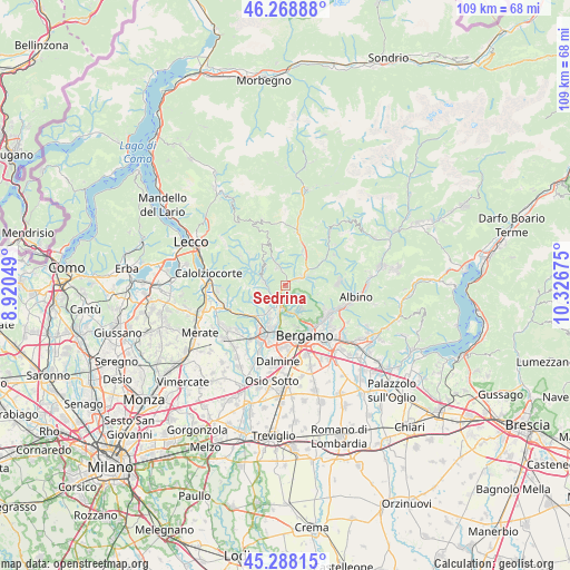
Sedrina GPS coordinates[2]
45° 46' 50.412" North, 9° 37' 25.032" East
| Map corner | latitude | longitude |
|---|---|---|
| Upper-left | 46.26888°, | 8.92049° |
| Center: | 45.78067°, | 9.62362° |
| Lower-right: | 45.28815°, | 10.32675° |
| Map W x H: | 109×109 km | = 67.7×67.7mi |
| max Lat: | 47.04031° ⇑15.1% North |
| Sedrina: | 45.78067° |
| min Lat: | ⇓84.9% South 35.50142° |
| min Long | Sedrina | max Long |
| 6.69888° | 9.62362° | 18.48682° |
| W 28.4%⇐ | ⇒71.6% E |
Elevation
Elevation of Sedrina is 336 m = 1102 ft, and this is 29.3 m = 96 ft above average elevation for this country.
| Max E: |
2085 m = 6841 ft | 35.8% |
| Sedrina | 336 m 1102 ft | |
| Avg. | 306.7 m = 1006 ft | |
Min E: |
-4 m = -13 ft | 64.2% |
See also: Italy elevation on elevation.city.
Geographical zone
Sedrina is located in North temperate zone (between Tropic of Cancer and the Arctic Circle). Distance of this North polar circle is 2310.8 km =1435.9 mi to North.| Distance of | km | miles | from Sedrina |
|---|---|---|---|
| North Pole | 4916.7 | 3055.1 | to North |
| Arctic Circle | 2310.8 | 1435.9 | to North |
| Tropic Cancer | 2484.4 | 1543.7 | to South |
| Equator | 5090.3 | 3163 | to South |


Nearby cities:
15 places around Sedrina: (largest is in red/bold)
• Almenno San Salvatore
4 km =2.5 mi,  210°
210°
• Almè
4.7 km =2.9 mi,  187°
187°
• Ambria-Spino
5.4 km =3.4 mi,  54°
54°
• Botta
1.6 km =1 mi, 207°
• Brembilla
5 km =3.1 mi,  335°
335°
• Camoneone
4.3 km =2.7 mi,  277°
277°
• Laxolo
3.6 km =2.2 mi,  329°
329°
• Poscante
5 km =3.1 mi,  85°
85°
• Roncola
5.1 km =3.2 mi,  254°
254°
• Sorisole
5.6 km =3.5 mi,  169°
169°
• Strozza
3.6 km =2.2 mi,  256°
256°
• Ubiale
0.6 km =0.4 mi,  299°
299°
• Ubiale Clanezzo
0.5 km =0.3 mi,  315°
315°
• Villa d'Almè
3.6 km =2.2 mi, 188°
• Zogno
3.2 km =2 mi,  62°
62°
Sources, notices
• [Note1] Compared only with cities in Italy existing in our database
• [Src1] Map data: © OpenStreetMap contributors (CC-BY-SA)
• [Src2] Other city data from geonames.org with taken over terms of usage.
• [Src3] Geographical zone / Annual Mean Temperature by Robert A. Rohde @ Wikipedia
