Botta geodata
Botta (Lombardy) is a populated place; located in Italy in Europe/Rome (GMT+2) time zone. With population of 753 people, there are 7932 cities with bigger population in this country. Compared to other cities in Italy, 84.4% of cities are located further ↓South; 71.8% of cities are located further →East and 65.6% of cities have lower elevation than Botta. Note1


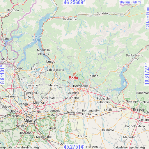
Botta GPS coordinates[2]
45° 46' 3.972" North, 9° 36' 50.904" East
| Map corner | latitude | longitude |
|---|---|---|
| Upper-left | 46.25609°, | 8.91101° |
| Center: | 45.76777°, | 9.61414° |
| Lower-right: | 45.27514°, | 10.31727° |
| Map W x H: | 109.1×109.1 km | = 67.8×67.8mi |
| max Lat: | 47.04031° ⇑15.6% North |
| Botta: | 45.76777° |
| min Lat: | ⇓84.4% South 35.50142° |
| min Long | Botta | max Long |
| 6.69888° | 9.61414° | 18.48682° |
| W 28.2%⇐ | ⇒71.8% E |
Elevation
Elevation of Botta is 349 m = 1145 ft, and this is 42.3 m = 139 ft above average elevation for this country.
| Max E: |
2085 m = 6841 ft | 34.4% |
| Botta | 349 m 1145 ft | |
| Avg. | 306.7 m = 1006 ft | |
Min E: |
-4 m = -13 ft | 65.6% |
See also: Italy elevation on elevation.city.
Geographical zone
Botta is located in North temperate zone (between Tropic of Cancer and the Arctic Circle). Distance of this North polar circle is 2312.3 km =1436.8 mi to North.| Distance of | km | miles | from Botta |
|---|---|---|---|
| North Pole | 4918.2 | 3056 | to North |
| Arctic Circle | 2312.3 | 1436.8 | to North |
| Tropic Cancer | 2483 | 1542.9 | to South |
| Equator | 5088.9 | 3162.1 | to South |


Nearby cities:
15 places around Botta: (largest is in red/bold)
• Almenno San Bartolomeo
4.1 km =2.5 mi,  219°
219°
• Almenno San Salvatore
2.4 km =1.5 mi,  213°
213°
• Almè
3.2 km =2 mi,  178°
178°
• Camoneone
4 km =2.5 mi,  299°
299°
• Laxolo
4.7 km =2.9 mi,  346°
346°
• Paladina
4.2 km =2.6 mi,  188°
188°
• Ponteranica
4.9 km =3 mi,  143°
143°
• Roncola
4.2 km =2.6 mi,  271°
271°
• Sedrina
1.6 km =1 mi,  27°
27°
• Sorisole
4.4 km =2.7 mi,  156°
156°
• Strozza
2.8 km =1.7 mi,  281°
281°
• Ubiale
1.8 km =1.1 mi,  5°
5°
• Ubiale Clanezzo
1.8 km =1.1 mi, 12°
• Villa d'Almè
2.2 km =1.4 mi,  174°
174°
• Zogno
4.6 km =2.9 mi,  50°
50°
Sources, notices
• [Note1] Compared only with cities in Italy existing in our database
• [Src1] Map data: © OpenStreetMap contributors (CC-BY-SA)
• [Src2] Other city data from geonames.org with taken over terms of usage.
• [Src3] Geographical zone / Annual Mean Temperature by Robert A. Rohde @ Wikipedia
