Almenno San Salvatore geodata
Almenno San Salvatore (Lombardy) is a seat of a third-order administrative division; located in Italy in Europe/Rome (GMT+2) time zone. With population of 5,670 people, there are 1735 cities with bigger population in this country. Compared to other cities in Italy, 83.6% of cities are located further ↓South; 72% of cities are located further →East and 59.4% of cities have lower elevation than Almenno San Salvatore. Note1
Administrative division(s):
- Level 1: Lombardy
- Level 2: Provincia di Bergamo
- Level 3: Almenno San Salvatore
Current local time in Almenno San Salvatore:
06:27 PM, WednesdayDifference from your time zone: hours


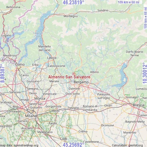
Almenno San Salvatore GPS coordinates[2]
45° 44' 58.956" North, 9° 35' 49.164" East
| Map corner | latitude | longitude |
|---|---|---|
| Upper-left | 46.23819°, | 8.89387° |
| Center: | 45.74971°, | 9.59699° |
| Lower-right: | 45.25692°, | 10.30012° |
| Map W x H: | 109.1×109.1 km | = 67.8×67.8mi |
| max Lat: | 47.04031° ⇑16.4% North |
| Almenno San Salvatore: | 45.74971° |
| min Lat: | ⇓83.6% South 35.50142° |
| min Long | Almenno San Sal | max Long |
| 6.69888° | 9.59699° | 18.48682° |
| W 28%⇐ | ⇒72% E |
Elevation
Elevation of Almenno San Salvatore is 295 m = 968 ft, and this is 11.7 m = 38 ft below average elevation for this country.
| Max E: |
2085 m = 6841 ft | 40.6% |
| Avg. | 306.7 m = 1006 ft | |
| Almenno San Salvatore | 295 m = 968 ft | |
Min E: |
-4 m = -13 ft | 59.4% |
See also: Italy elevation on elevation.city.
Geographical zone
Almenno San Salvatore is located in North temperate zone (between Tropic of Cancer and the Arctic Circle). Distance of this North polar circle is 2314.3 km =1438 mi to North.| Distance of | km | miles | from Almenno San Salvatore |
|---|---|---|---|
| North Pole | 4920.2 | 3057.3 | to North |
| Arctic Circle | 2314.3 | 1438 | to North |
| Tropic Cancer | 2481 | 1541.6 | to South |
| Equator | 5086.9 | 3160.9 | to South |


Nearby cities:
15 places around Almenno San Salvatore: (largest is in red/bold)
• Almenno San Bartolomeo
1.7 km =1.1 mi,  226°
226°
• Almè
1.9 km =1.2 mi,  129°
129°
• Barzana
2.9 km =1.8 mi, 230°
• Botta
2.4 km =1.5 mi,  33°
33°
• Brembate di Sopra
3.9 km =2.4 mi,  200°
200°
• Camoneone
4.5 km =2.8 mi,  331°
331°
• Paladina
2.2 km =1.4 mi,  161°
161°
• Roncola
3.5 km =2.2 mi,  306°
306°
• Scano al Brembo
3.6 km =2.2 mi, 164°
• Sedrina
4 km =2.5 mi, 30°
• Sorisole
3.7 km =2.3 mi,  123°
123°
• Strozza
2.9 km =1.8 mi, 331°
• Ubiale
4.1 km =2.5 mi,  21°
21°
• Ubiale Clanezzo
4.2 km =2.6 mi, 24°
• Villa d'Almè
1.6 km =1 mi,  95°
95°
Sources, notices
• [Note1] Compared only with cities in Italy existing in our database
• [Src1] Map data: © OpenStreetMap contributors (CC-BY-SA)
• [Src2] Other city data from geonames.org with taken over terms of usage.
• [Src3] Geographical zone / Annual Mean Temperature by Robert A. Rohde @ Wikipedia
