Bargagli geodata
Bargagli (Liguria) is a seat of a third-order administrative division; located in Italy in Europe/Rome (GMT+2) time zone. With population of 1,781 people, there are 4515 cities with bigger population in this country. Compared to other cities in Italy, 50.3% of cities are located further ↓South; 79.8% of cities are located further →East and 79.4% of cities have lower elevation than Bargagli. Note1


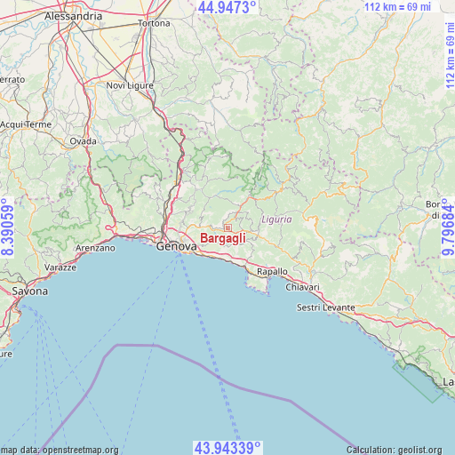
Bargagli GPS coordinates[2]
44° 26' 51" North, 9° 5' 37.392" East
| Map corner | latitude | longitude |
|---|---|---|
| Upper-left | 44.9473°, | 8.39059° |
| Center: | 44.4475°, | 9.09372° |
| Lower-right: | 43.94339°, | 9.79684° |
| Map W x H: | 111.6×111.6 km | = 69.3×69.3mi |
| max Lat: | 47.04031° ⇑49.7% North |
| Bargagli: | 44.4475° |
| min Lat: | ⇓50.3% South 35.50142° |
| min Long | Bargagli | max Long |
| 6.69888° | 9.09372° | 18.48682° |
| W 20.2%⇐ | ⇒79.8% E |
Elevation
Elevation of Bargagli is 516 m = 1693 ft, and this is 209.3 m = 687 ft above average elevation for this country.
| Max E: |
2085 m = 6841 ft | 20.6% |
| Bargagli | 516 m 1693 ft | |
| Avg. | 306.7 m = 1006 ft | |
Min E: |
-4 m = -13 ft | 79.4% |
See also: Italy elevation on elevation.city.
Geographical zone
Bargagli is located in North temperate zone (between Tropic of Cancer and the Arctic Circle). Distance of this Northern Tropic circle is 2336.2 km =1451.6 mi to South.| Distance of | km | miles | from Bargagli |
|---|---|---|---|
| North Pole | 5065 | 3147.2 | to North |
| Arctic Circle | 2459.1 | 1528 | to North |
| Tropic Cancer | 2336.2 | 1451.6 | to South |
| Equator | 4942.1 | 3070.9 | to South |


Nearby cities:
15 places around Bargagli: (largest is in red/bold)
• Avegno
8.8 km =5.5 mi,  144°
144°
• Avegno Chiesa
8.7 km =5.4 mi, 140°
• Bogliasco
7.7 km =4.8 mi,  194°
194°
• Davagna
2.1 km =1.3 mi,  344°
344°
• Ferriere
3.5 km =2.2 mi,  98°
98°
• Gattorna
7.5 km =4.7 mi, 104°
• Montoggio
8.5 km =5.3 mi, 335°
• Neirone
7.8 km =4.8 mi,  84°
84°
• Pieve Ligure
8.1 km =5 mi,  179°
179°
• Poggio Favaro-San Bernardo
7.3 km =4.5 mi, 189°
• Sori
8.3 km =5.2 mi,  173°
173°
• Testana
7.1 km =4.4 mi, 144°
• Torriglia
9.3 km =5.8 mi,  33°
33°
• Tribogna
8.8 km =5.5 mi,  113°
113°
• Uscio
6.7 km =4.2 mi,  125°
125°
Sources, notices
• [Note1] Compared only with cities in Italy existing in our database
• [Src1] Map data: © OpenStreetMap contributors (CC-BY-SA)
• [Src2] Other city data from geonames.org with taken over terms of usage.
• [Src3] Geographical zone / Annual Mean Temperature by Robert A. Rohde @ Wikipedia
