Soresina geodata
Soresina (Lombardy) is a seat of a third-order administrative division; located in Italy in Europe/Rome (GMT+2) time zone. With population of 8,700 people, there are 1097 cities with bigger population in this country. Compared to other cities in Italy, 67.1% of cities are located further ↓South; 69.3% of cities are located further →East and 75.9% of cities have higher elevation than Soresina. Note1


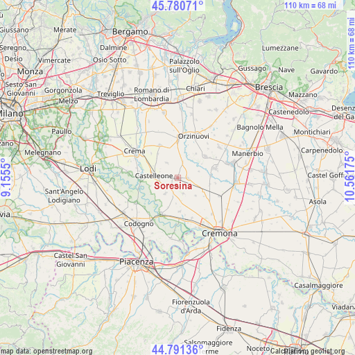
Soresina GPS coordinates[2]
45° 17' 17.484" North, 9° 51' 31.032" East
| Map corner | latitude | longitude |
|---|---|---|
| Upper-left | 45.78071°, | 9.1555° |
| Center: | 45.28819°, | 9.85862° |
| Lower-right: | 44.79136°, | 10.56175° |
| Map W x H: | 110×110 km | = 68.4×68.4mi |
| max Lat: | 47.04031° ⇑32.9% North |
| Soresina: | 45.28819° |
| min Lat: | ⇓67.1% South 35.50142° |
| min Long | Soresina | max Long |
| 6.69888° | 9.85862° | 18.48682° |
| W 30.7%⇐ | ⇒69.3% E |
Elevation
Elevation of Soresina is 70 m = 230 ft, and this is 236.7 m = 777 ft below average elevation for this country.
| Max E: |
2085 m = 6841 ft | 75.9% |
| Avg. | 306.7 m = 1006 ft | |
| Soresina | 70 m = 230 ft | |
Min E: |
-4 m = -13 ft | 24.1% |
See also: Italy elevation on elevation.city.
Geographical zone
Soresina is located in North temperate zone (between Tropic of Cancer and the Arctic Circle). Distance of this North polar circle is 2365.6 km =1469.9 mi to North.| Distance of | km | miles | from Soresina |
|---|---|---|---|
| North Pole | 4971.5 | 3089.1 | to North |
| Arctic Circle | 2365.6 | 1469.9 | to North |
| Tropic Cancer | 2429.7 | 1509.7 | to South |
| Equator | 5035.6 | 3129 | to South |


Nearby cities:
15 places around Soresina: (largest is in red/bold)
• Annicco
5.2 km =3.2 mi,  162°
162°
• Azzanello
5.5 km =3.4 mi,  59°
59°
• Cappella Cantone
4.9 km =3 mi,  198°
198°
• Casalbuttano
9 km =5.6 mi,  116°
116°
• Casalmorano
3.1 km =1.9 mi,  91°
91°
• Castelleone
7.7 km =4.8 mi,  276°
276°
• Castelvisconti
6.7 km =4.2 mi,  73°
73°
• Cumignano sul Naviglio
7.6 km =4.7 mi,  346°
346°
• Fiesco
8.4 km =5.2 mi,  310°
310°
• Genivolta
5.1 km =3.2 mi,  16°
16°
• Paderno Ponchielli
7.8 km =4.8 mi,  135°
135°
• San Bassano
6.3 km =3.9 mi,  217°
217°
• Santa Maria dei Sabbioni
5.2 km =3.2 mi, 197°
• Trigolo
5.8 km =3.6 mi,  323°
323°
• Villachiara
9.3 km =5.8 mi,  37°
37°
Sources, notices
• [Note1] Compared only with cities in Italy existing in our database
• [Src1] Map data: © OpenStreetMap contributors (CC-BY-SA)
• [Src2] Other city data from geonames.org with taken over terms of usage.
• [Src3] Geographical zone / Annual Mean Temperature by Robert A. Rohde @ Wikipedia
