Castelleone geodata
Castelleone (Lombardy) is a seat of a third-order administrative division; located in Italy in Europe/Rome (GMT+2) time zone. With population of 8,198 people, there are 1180 cities with bigger population in this country. Compared to other cities in Italy, 67.4% of cities are located further ↓South; 70.1% of cities are located further →East and 78.3% of cities have higher elevation than Castelleone. Note1


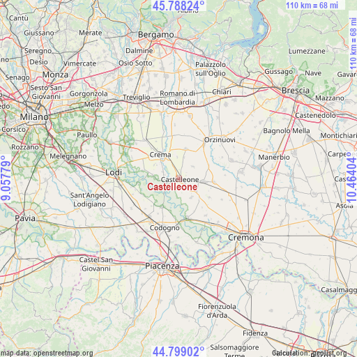
Castelleone GPS coordinates[2]
45° 17' 44.844" North, 9° 45' 39.276" East
| Map corner | latitude | longitude |
|---|---|---|
| Upper-left | 45.78824°, | 9.05779° |
| Center: | 45.29579°, | 9.76091° |
| Lower-right: | 44.79902°, | 10.46404° |
| Map W x H: | 110×110 km | = 68.4×68.4mi |
| max Lat: | 47.04031° ⇑32.6% North |
| Castelleone: | 45.29579° |
| min Lat: | ⇓67.4% South 35.50142° |
| min Long | Castelleone | max Long |
| 6.69888° | 9.76091° | 18.48682° |
| W 29.9%⇐ | ⇒70.1% E |
Elevation
Elevation of Castelleone is 58 m = 190 ft, and this is 248.7 m = 816 ft below average elevation for this country.
| Max E: |
2085 m = 6841 ft | 78.3% |
| Avg. | 306.7 m = 1006 ft | |
| Castelleone | 58 m = 190 ft | |
Min E: |
-4 m = -13 ft | 21.7% |
See also: Italy elevation on elevation.city.
Geographical zone
Castelleone is located in North temperate zone (between Tropic of Cancer and the Arctic Circle). Distance of this North polar circle is 2364.8 km =1469.4 mi to North.| Distance of | km | miles | from Castelleone |
|---|---|---|---|
| North Pole | 4970.6 | 3088.6 | to North |
| Arctic Circle | 2364.8 | 1469.4 | to North |
| Tropic Cancer | 2430.5 | 1510.2 | to South |
| Equator | 5036.4 | 3129.5 | to South |


Nearby cities:
15 places around Castelleone: (largest is in red/bold)
• Fiesco
4.8 km =3 mi,  15°
15°
• Formigara
8.1 km =5 mi,  174°
174°
• Gombito
4.5 km =2.8 mi,  213°
213°
• Izano
6.7 km =4.2 mi,  353°
353°
• Madignano
6.2 km =3.9 mi,  331°
331°
• Montodine
4.3 km =2.7 mi,  252°
252°
• Moscazzano
6.2 km =3.9 mi,  267°
267°
• Ripalta Arpina
2.6 km =1.6 mi,  285°
285°
• Ripalta Guerina
4.6 km =2.9 mi,  284°
284°
• Ripalta Nuova
6.7 km =4.2 mi,  306°
306°
• Salvirola
6.9 km =4.3 mi,  12°
12°
• San Bassano
6.9 km =4.3 mi,  146°
146°
• Soresina
7.7 km =4.8 mi,  96°
96°
• Trigolo
5.6 km =3.5 mi,  47°
47°
• Zappello
8 km =5 mi,  301°
301°
Sources, notices
• [Note1] Compared only with cities in Italy existing in our database
• [Src1] Map data: © OpenStreetMap contributors (CC-BY-SA)
• [Src2] Other city data from geonames.org with taken over terms of usage.
• [Src3] Geographical zone / Annual Mean Temperature by Robert A. Rohde @ Wikipedia
