Cappella Cantone geodata
Cappella Cantone (Lombardy) is a seat of a third-order administrative division; located in Italy in Europe/Rome (GMT+2) time zone. With population of 534 people, there are 9605 cities with bigger population in this country. Compared to other cities in Italy, 66.1% of cities are located further ↓South; 69.5% of cities are located further →East and 78.1% of cities have higher elevation than Cappella Cantone. Note1
Administrative division(s):
- Level 1: Lombardy
- Level 2: Provincia di Cremona
- Level 3: Cappella Cantone


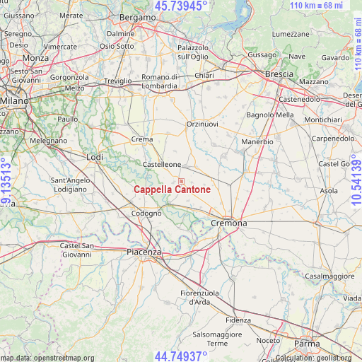
Cappella Cantone GPS coordinates[2]
45° 14' 47.652" North, 9° 50' 17.736" East
| Map corner | latitude | longitude |
|---|---|---|
| Upper-left | 45.73945°, | 9.13513° |
| Center: | 45.24657°, | 9.83826° |
| Lower-right: | 44.74937°, | 10.54139° |
| Map W x H: | 110.1×110.1 km | = 68.4×68.4mi |
| max Lat: | 47.04031° ⇑33.9% North |
| Cappella Cantone: | 45.24657° |
| min Lat: | ⇓66.1% South 35.50142° |
| min Long | Cappella Canton | max Long |
| 6.69888° | 9.83826° | 18.48682° |
| W 30.5%⇐ | ⇒69.5% E |
Elevation
Elevation of Cappella Cantone is 59 m = 194 ft, and this is 247.7 m = 813 ft below average elevation for this country.
| Max E: |
2085 m = 6841 ft | 78.1% |
| Avg. | 306.7 m = 1006 ft | |
| Cappella Cantone | 59 m = 194 ft | |
Min E: |
-4 m = -13 ft | 21.9% |
See also: Italy elevation on elevation.city.
Geographical zone
Cappella Cantone is located in North temperate zone (between Tropic of Cancer and the Arctic Circle). Distance of this North polar circle is 2370.2 km =1472.8 mi to North.| Distance of | km | miles | from Cappella Cantone |
|---|---|---|---|
| North Pole | 4976.1 | 3092 | to North |
| Arctic Circle | 2370.2 | 1472.8 | to North |
| Tropic Cancer | 2425 | 1506.8 | to South |
| Equator | 5030.9 | 3126.1 | to South |


Nearby cities:
15 places around Cappella Cantone: (largest is in red/bold)
• Annicco
3.2 km =2 mi,  96°
96°
• Casalmorano
6.6 km =4.1 mi,  45°
45°
• Castelleone
8.2 km =5.1 mi,  312°
312°
• Fengo
8 km =5 mi,  151°
151°
• Formigara
5.9 km =3.7 mi,  243°
243°
• Gombito
8.8 km =5.5 mi,  281°
281°
• Grumello Cremonese
6.2 km =3.9 mi,  160°
160°
• Paderno Ponchielli
7.1 km =4.4 mi, 97°
• Pizzighettone
7.7 km =4.8 mi,  210°
210°
• Regona
4.8 km =3 mi,  198°
198°
• Roggione
7.4 km =4.6 mi, 199°
• San Bassano
2.3 km =1.4 mi,  262°
262°
• Santa Maria dei Sabbioni
0.3 km =0.2 mi,  165°
165°
• Soresina
4.9 km =3 mi,  18°
18°
• Trigolo
9.5 km =5.9 mi,  348°
348°
Sources, notices
• [Note1] Compared only with cities in Italy existing in our database
• [Src1] Map data: © OpenStreetMap contributors (CC-BY-SA)
• [Src2] Other city data from geonames.org with taken over terms of usage.
• [Src3] Geographical zone / Annual Mean Temperature by Robert A. Rohde @ Wikipedia
