Solopaca geodata
Solopaca (Campania) is a seat of a third-order administrative division; located in Italy in Europe/Rome (GMT+2) time zone. With population of 2,993 people, there are 3050 cities with bigger population in this country. Compared to other cities in Italy, 76.9% of cities are located further ↑North; 83.2% of cities are located further ←West and 61.6% of cities have higher elevation than Solopaca. Note1


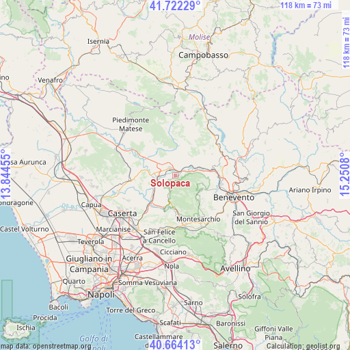
Solopaca GPS coordinates[2]
41° 11' 43.26" North, 14° 32' 51.612" East
| Map corner | latitude | longitude |
|---|---|---|
| Upper-left | 41.72229°, | 13.84455° |
| Center: | 41.19535°, | 14.54767° |
| Lower-right: | 40.66413°, | 15.2508° |
| Map W x H: | 117.7×117.7 km | = 73.1×73.1mi |
| max Lat: | 47.04031° ⇑76.9% North |
| Solopaca: | 41.19535° |
| min Lat: | ⇓23.1% South 35.50142° |
| min Long | Solopaca | max Long |
| 6.69888° | 14.54767° | 18.48682° |
| W 83.2%⇐ | ⇒16.8% E |
Elevation
Elevation of Solopaca is 151 m = 495 ft, and this is 155.7 m = 511 ft below average elevation for this country.
| Max E: |
2085 m = 6841 ft | 61.6% |
| Avg. | 306.7 m = 1006 ft | |
| Solopaca | 151 m = 495 ft | |
Min E: |
-4 m = -13 ft | 38.4% |
See also: Italy elevation on elevation.city.
Geographical zone
Solopaca is located in North temperate zone (between Tropic of Cancer and the Arctic Circle). Distance of this Northern Tropic circle is 1974.6 km =1227 mi to South.| Distance of | km | miles | from Solopaca |
|---|---|---|---|
| North Pole | 5426.6 | 3371.9 | to North |
| Arctic Circle | 2820.7 | 1752.7 | to North |
| Tropic Cancer | 1974.6 | 1227 | to South |
| Equator | 4580.5 | 2846.2 | to South |


Nearby cities:
15 places around Solopaca: (largest is in red/bold)
• Amorosi
6.9 km =4.3 mi,  276°
276°
• Castel Campagnano
8.1 km =5 mi,  259°
259°
• Castelvenere
4.3 km =2.7 mi,  359°
359°
• Cautano
9.5 km =5.9 mi,  121°
121°
• Frasso Telesino
4.6 km =2.9 mi,  201°
201°
• Guardia Sanframondi
8 km =5 mi,  32°
32°
• Melizzano
5.1 km =3.2 mi,  223°
223°
• Puglianello
8.7 km =5.4 mi,  289°
289°
• San Lorenzello
9 km =5.6 mi, 356°
• San Lorenzo Maggiore
8.7 km =5.4 mi,  47°
47°
• San Salvatore Telesino
6.1 km =3.8 mi,  317°
317°
• Telese
3 km =1.9 mi, 324°
• Via Fausto Coppi
2.3 km =1.4 mi,  314°
314°
• Via S. Giovanni
3.6 km =2.2 mi,  303°
303°
• Vitulano
8.7 km =5.4 mi,  105°
105°
Sources, notices
• [Note1] Compared only with cities in Italy existing in our database
• [Src1] Map data: © OpenStreetMap contributors (CC-BY-SA)
• [Src2] Other city data from geonames.org with taken over terms of usage.
• [Src3] Geographical zone / Annual Mean Temperature by Robert A. Rohde @ Wikipedia
