Telese geodata
Telese (Campania) is a seat of a third-order administrative division; located in Italy in Europe/Rome (GMT+2) time zone. With population of 5,120 people, there are 1914 cities with bigger population in this country. Compared to other cities in Italy, 76.8% of cities are located further ↑North; 82.9% of cities are located further ←West and 78.5% of cities have higher elevation than Telese. Note1


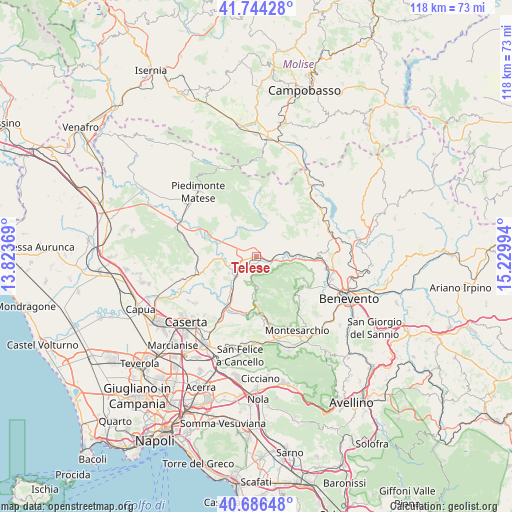
Telese GPS coordinates[2]
41° 13' 3.072" North, 14° 31' 36.516" East
| Map corner | latitude | longitude |
|---|---|---|
| Upper-left | 41.74428°, | 13.82369° |
| Center: | 41.21752°, | 14.52681° |
| Lower-right: | 40.68648°, | 15.22994° |
| Map W x H: | 117.6×117.6 km | = 73.1×73.1mi |
| max Lat: | 47.04031° ⇑76.8% North |
| Telese: | 41.21752° |
| min Lat: | ⇓23.2% South 35.50142° |
| min Long | Telese | max Long |
| 6.69888° | 14.52681° | 18.48682° |
| W 82.9%⇐ | ⇒17.1% E |
Elevation
Elevation of Telese is 57 m = 187 ft, and this is 249.7 m = 819 ft below average elevation for this country.
| Max E: |
2085 m = 6841 ft | 78.5% |
| Avg. | 306.7 m = 1006 ft | |
| Telese | 57 m = 187 ft | |
Min E: |
-4 m = -13 ft | 21.5% |
See also: Italy elevation on elevation.city.
Geographical zone
Telese is located in North temperate zone (between Tropic of Cancer and the Arctic Circle). Distance of this Northern Tropic circle is 1977 km =1228.5 mi to South.| Distance of | km | miles | from Telese |
|---|---|---|---|
| North Pole | 5424.1 | 3370.4 | to North |
| Arctic Circle | 2818.2 | 1751.1 | to North |
| Tropic Cancer | 1977 | 1228.5 | to South |
| Equator | 4583 | 2847.7 | to South |


Nearby cities:
15 places around Telese: (largest is in red/bold)
• Amorosi
5.3 km =3.3 mi,  252°
252°
• Castel Campagnano
7.3 km =4.5 mi,  237°
237°
• Castelvenere
2.6 km =1.6 mi,  42°
42°
• Cerreto Sannita
7.8 km =4.8 mi,  21°
21°
• Faicchio
7.9 km =4.9 mi,  328°
328°
• Frasso Telesino
6.7 km =4.2 mi,  179°
179°
• Guardia Sanframondi
7.4 km =4.6 mi,  54°
54°
• Melizzano
6.4 km =4 mi,  196°
196°
• Puglianello
6.4 km =4 mi,  274°
274°
• San Lorenzello
6.6 km =4.1 mi,  10°
10°
• San Lorenzo Maggiore
8.9 km =5.5 mi,  66°
66°
• San Salvatore Telesino
3.1 km =1.9 mi,  309°
309°
• Solopaca
3 km =1.9 mi,  144°
144°
• Via Fausto Coppi
0.8 km =0.5 mi,  174°
174°
• Via S. Giovanni
1.4 km =0.9 mi, 250°
Sources, notices
• [Note1] Compared only with cities in Italy existing in our database
• [Src1] Map data: © OpenStreetMap contributors (CC-BY-SA)
• [Src2] Other city data from geonames.org with taken over terms of usage.
• [Src3] Geographical zone / Annual Mean Temperature by Robert A. Rohde @ Wikipedia
