Melizzano geodata
Melizzano (Campania) is a seat of a third-order administrative division; located in Italy in Europe/Rome (GMT+2) time zone. With population of 843 people, there are 7431 cities with bigger population in this country. Compared to other cities in Italy, 77.2% of cities are located further ↑North; 82.7% of cities are located further ←West and 58.3% of cities have higher elevation than Melizzano. Note1


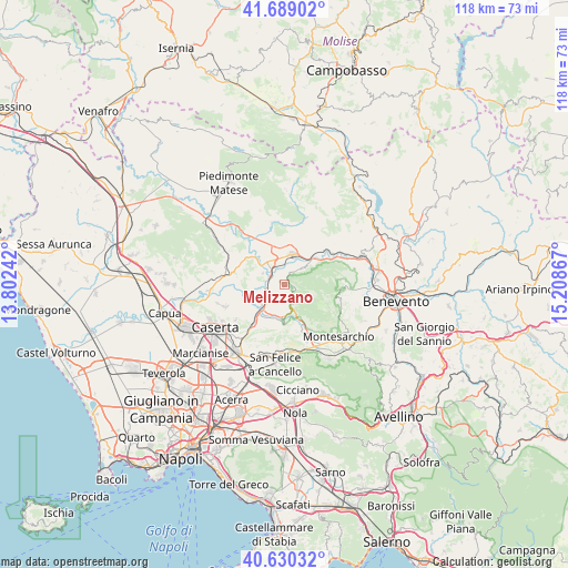
Melizzano GPS coordinates[2]
41° 9' 42.516" North, 14° 30' 19.944" East
| Map corner | latitude | longitude |
|---|---|---|
| Upper-left | 41.68902°, | 13.80242° |
| Center: | 41.16181°, | 14.50554° |
| Lower-right: | 40.63032°, | 15.20867° |
| Map W x H: | 117.7×117.7 km | = 73.1×73.1mi |
| max Lat: | 47.04031° ⇑77.2% North |
| Melizzano: | 41.16181° |
| min Lat: | ⇓22.8% South 35.50142° |
| min Long | Melizzano | max Long |
| 6.69888° | 14.50554° | 18.48682° |
| W 82.7%⇐ | ⇒17.3% E |
Elevation
Elevation of Melizzano is 177 m = 581 ft, and this is 129.7 m = 426 ft below average elevation for this country.
| Max E: |
2085 m = 6841 ft | 58.3% |
| Avg. | 306.7 m = 1006 ft | |
| Melizzano | 177 m = 581 ft | |
Min E: |
-4 m = -13 ft | 41.7% |
See also: Italy elevation on elevation.city.
Geographical zone
Melizzano is located in North temperate zone (between Tropic of Cancer and the Arctic Circle). Distance of this Northern Tropic circle is 1970.8 km =1224.6 mi to South.| Distance of | km | miles | from Melizzano |
|---|---|---|---|
| North Pole | 5430.3 | 3374.2 | to North |
| Arctic Circle | 2824.4 | 1755 | to North |
| Tropic Cancer | 1970.8 | 1224.6 | to South |
| Equator | 4576.8 | 2843.9 | to South |


Nearby cities:
15 places around Melizzano: (largest is in red/bold)
• Amorosi
5.6 km =3.5 mi,  323°
323°
• Castel Campagnano
5 km =3.1 mi,  297°
297°
• Castelvenere
8.8 km =5.5 mi,  23°
23°
• Dugenta
5.3 km =3.3 mi,  235°
235°
• Frasso Telesino
1.9 km =1.2 mi,  106°
106°
• Giardoni
8 km =5 mi,  233°
233°
• Limatola
9.6 km =6 mi,  255°
255°
• Moiano
9.7 km =6 mi,  160°
160°
• Puglianello
8.1 km =5 mi,  325°
325°
• San Salvatore Telesino
8.2 km =5.1 mi,  355°
355°
• Sant'Agata de'Goti
8.1 km =5 mi,  184°
184°
• Solopaca
5.1 km =3.2 mi,  43°
43°
• Telese
6.4 km =4 mi, 16°
• Via Fausto Coppi
5.7 km =3.5 mi, 19°
• Via S. Giovanni
5.8 km =3.6 mi,  4°
4°
Sources, notices
• [Note1] Compared only with cities in Italy existing in our database
• [Src1] Map data: © OpenStreetMap contributors (CC-BY-SA)
• [Src2] Other city data from geonames.org with taken over terms of usage.
• [Src3] Geographical zone / Annual Mean Temperature by Robert A. Rohde @ Wikipedia
