San Salvatore Telesino geodata
San Salvatore Telesino (Campania) is a seat of a third-order administrative division; located in Italy in Europe/Rome (GMT+2) time zone. With population of 2,184 people, there are 3895 cities with bigger population in this country. Compared to other cities in Italy, 76.6% of cities are located further ↑North; 82.6% of cities are located further ←West and 71.6% of cities have higher elevation than San Salvatore Telesino. Note1
Administrative division(s):
- Level 1: Campania
- Level 2: Provincia di Benevento
- Level 3: San Salvatore Telesino
Current local time in San Salvatore Telesino:
09:41 PM, WednesdayDifference from your time zone: hours


San Salvatore Telesino GPS coordinates[2]
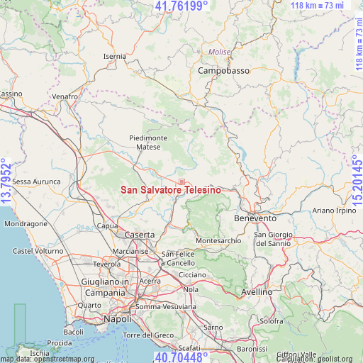
41° 14' 7.332" North, 14° 29' 53.952" East
| Map corner | latitude | longitude |
|---|---|---|
| Upper-left | 41.76199°, | 13.7952° |
| Center: | 41.23537°, | 14.49832° |
| Lower-right: | 40.70448°, | 15.20145° |
| Map W x H: | 117.6×117.6 km | = 73.1×73.1mi |
| max Lat: | 47.04031° ⇑76.6% North |
| San Salvatore Telesino: | 41.23537° |
| min Lat: | ⇓23.4% South 35.50142° |
| min Long | San Salvatore T | max Long |
| 6.69888° | 14.49832° | 18.48682° |
| W 82.6%⇐ | ⇒17.4% E |
Elevation
Elevation of San Salvatore Telesino is 89 m = 292 ft, and this is 217.7 m = 714 ft below average elevation for this country.
| Max E: |
2085 m = 6841 ft | 71.6% |
| Avg. | 306.7 m = 1006 ft | |
| San Salvatore Telesino | 89 m = 292 ft | |
Min E: |
-4 m = -13 ft | 28.4% |
See also: Italy elevation on elevation.city.
Geographical zone
San Salvatore Telesino is located in North temperate zone (between Tropic of Cancer and the Arctic Circle). Distance of this Northern Tropic circle is 1979 km =1229.7 mi to South.| Distance of | km | miles | from San Salvatore Telesino |
|---|---|---|---|
| North Pole | 5422.1 | 3369.1 | to North |
| Arctic Circle | 2816.2 | 1749.9 | to North |
| Tropic Cancer | 1979 | 1229.7 | to South |
| Equator | 4584.9 | 2848.9 | to South |


Nearby cities:
15 places around San Salvatore Telesino: (largest is in red/bold)
• Amorosi
4.5 km =2.8 mi,  216°
216°
• Castel Campagnano
7 km =4.3 mi,  212°
212°
• Castelvenere
4.1 km =2.5 mi,  91°
91°
• Cerreto Sannita
7.5 km =4.7 mi,  44°
44°
• Faicchio
5.1 km =3.2 mi,  339°
339°
• Gioia Sannitica
8.5 km =5.3 mi,  327°
327°
• Guardia Sanframondi
8.7 km =5.4 mi,  74°
74°
• Melizzano
8.2 km =5.1 mi,  175°
175°
• Puglianello
4.3 km =2.7 mi,  249°
249°
• Ruviano
7.9 km =4.9 mi, 249°
• San Lorenzello
5.8 km =3.6 mi, 38°
• Solopaca
6.1 km =3.8 mi,  137°
137°
• Telese
3.1 km =1.9 mi,  129°
129°
• Via Fausto Coppi
3.7 km =2.3 mi, 138°
• Via S. Giovanni
2.7 km =1.7 mi,  156°
156°
Sources, notices
• [Note1] Compared only with cities in Italy existing in our database
• [Src1] Map data: © OpenStreetMap contributors (CC-BY-SA)
• [Src2] Other city data from geonames.org with taken over terms of usage.
• [Src3] Geographical zone / Annual Mean Temperature by Robert A. Rohde @ Wikipedia
