Sirolo geodata
Sirolo (The Marches) is a seat of a third-order administrative division; located in Italy in Europe/Rome (GMT+2) time zone. With population of 2,545 people, there are 3475 cities with bigger population in this country. Compared to other cities in Italy, 59.7% of cities are located further ↑North; 74.8% of cities are located further ←West and 70% of cities have higher elevation than Sirolo. Note1


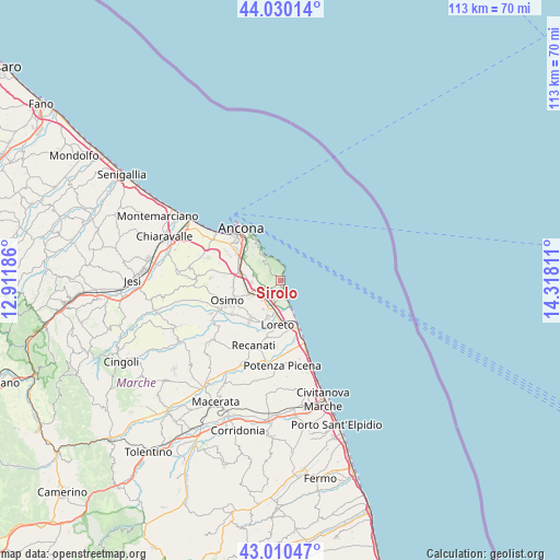
Sirolo GPS coordinates[2]
43° 31' 20.856" North, 13° 36' 53.928" East
| Map corner | latitude | longitude |
|---|---|---|
| Upper-left | 44.03014°, | 12.91186° |
| Center: | 43.52246°, | 13.61498° |
| Lower-right: | 43.01047°, | 14.31811° |
| Map W x H: | 113.4×113.4 km | = 70.5×70.5mi |
| max Lat: | 47.04031° ⇑59.7% North |
| Sirolo: | 43.52246° |
| min Lat: | ⇓40.3% South 35.50142° |
| min Long | Sirolo | max Long |
| 6.69888° | 13.61498° | 18.48682° |
| W 74.8%⇐ | ⇒25.2% E |
Elevation
Elevation of Sirolo is 97 m = 318 ft, and this is 209.7 m = 688 ft below average elevation for this country.
| Max E: |
2085 m = 6841 ft | 70% |
| Avg. | 306.7 m = 1006 ft | |
| Sirolo | 97 m = 318 ft | |
Min E: |
-4 m = -13 ft | 30% |
See also: Italy elevation on elevation.city.
Geographical zone
Sirolo is located in North temperate zone (between Tropic of Cancer and the Arctic Circle). Distance of this Northern Tropic circle is 2233.3 km =1387.7 mi to South.| Distance of | km | miles | from Sirolo |
|---|---|---|---|
| North Pole | 5167.8 | 3211.1 | to North |
| Arctic Circle | 2561.9 | 1591.9 | to North |
| Tropic Cancer | 2233.3 | 1387.7 | to South |
| Equator | 4839.2 | 3006.9 | to South |


Nearby cities:
15 places around Sirolo: (largest is in red/bold)
• Abbadia
7.4 km =4.6 mi,  238°
238°
• Aspio
9.3 km =5.8 mi,  277°
277°
• Camerano
5.1 km =3.2 mi, 276°
• Castelfidardo
8.8 km =5.5 mi,  216°
216°
• Loreto
9.6 km =6 mi,  181°
181°
• Loreto Stazione
8.3 km =5.2 mi, 177°
• Marcelli
3.5 km =2.2 mi,  165°
165°
• Musone
8.9 km =5.5 mi,  192°
192°
• Numana
1.3 km =0.8 mi,  157°
157°
• Ponte dell'Aspio
9.4 km =5.8 mi,  274°
274°
• San Biagio
9.6 km =6 mi, 265°
• San Rocchetto
5.5 km =3.4 mi, 221°
• Varano
7.6 km =4.7 mi,  313°
313°
• Villa Musone
8.5 km =5.3 mi, 186°
• Villaggio Taunus
2.4 km =1.5 mi, 188°
Sources, notices
• [Note1] Compared only with cities in Italy existing in our database
• [Src1] Map data: © OpenStreetMap contributors (CC-BY-SA)
• [Src2] Other city data from geonames.org with taken over terms of usage.
• [Src3] Geographical zone / Annual Mean Temperature by Robert A. Rohde @ Wikipedia
