Varano geodata
Varano (The Marches) is a populated place; located in Italy in Europe/Rome (GMT+2) time zone. With population of 591 people, there are 9082 cities with bigger population in this country. Compared to other cities in Italy, 59.2% of cities are located further ↑North; 74.1% of cities are located further ←West and 59% of cities have higher elevation than Varano. Note1


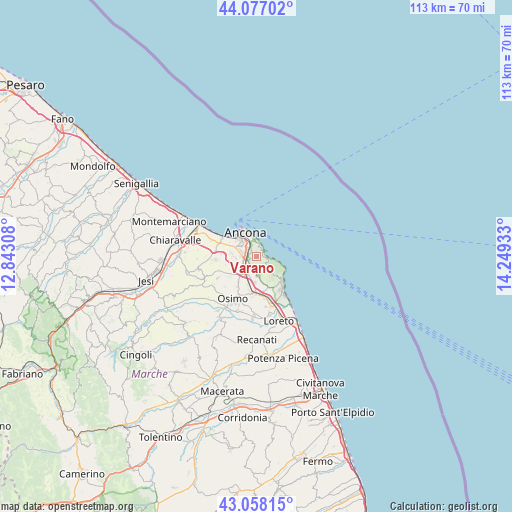
Varano GPS coordinates[2]
43° 34' 11.064" North, 13° 32' 46.32" East
| Map corner | latitude | longitude |
|---|---|---|
| Upper-left | 44.07702°, | 12.84308° |
| Center: | 43.56974°, | 13.5462° |
| Lower-right: | 43.05815°, | 14.24933° |
| Map W x H: | 113.3×113.3 km | = 70.4×70.4mi |
| max Lat: | 47.04031° ⇑59.2% North |
| Varano: | 43.56974° |
| min Lat: | ⇓40.8% South 35.50142° |
| min Long | Varano | max Long |
| 6.69888° | 13.5462° | 18.48682° |
| W 74.1%⇐ | ⇒25.9% E |
Elevation
Elevation of Varano is 171 m = 561 ft, and this is 135.7 m = 445 ft below average elevation for this country.
| Max E: |
2085 m = 6841 ft | 59% |
| Avg. | 306.7 m = 1006 ft | |
| Varano | 171 m = 561 ft | |
Min E: |
-4 m = -13 ft | 41% |
See also: Italy elevation on elevation.city.
Geographical zone
Varano is located in North temperate zone (between Tropic of Cancer and the Arctic Circle). Distance of this Northern Tropic circle is 2238.6 km =1391 mi to South.| Distance of | km | miles | from Varano |
|---|---|---|---|
| North Pole | 5162.6 | 3207.9 | to North |
| Arctic Circle | 2556.7 | 1588.7 | to North |
| Tropic Cancer | 2238.6 | 1391 | to South |
| Equator | 4844.5 | 3010.2 | to South |


Nearby cities:
15 places around Varano: (largest is in red/bold)
• Abbadia
9.1 km =5.7 mi,  184°
184°
• Ancona
4.4 km =2.7 mi,  308°
308°
• Aspio
5.4 km =3.4 mi,  223°
223°
• Camerano
4.7 km =2.9 mi,  173°
173°
• Candia
4.3 km =2.7 mi,  263°
263°
• Le Grazie di Ancona
4.3 km =2.7 mi,  324°
324°
• Numana
8.9 km =5.5 mi,  137°
137°
• Pietra la Croce
3.7 km =2.3 mi,  350°
350°
• Pinocchio di Ancona
4.8 km =3 mi,  298°
298°
• Ponte dell'Aspio
5.9 km =3.7 mi, 220°
• Posatora
5.6 km =3.5 mi, 305°
• San Biagio
7.2 km =4.5 mi,  213°
213°
• San Rocchetto
9.6 km =6 mi, 168°
• Sirolo
7.6 km =4.7 mi,  133°
133°
• Villaggio Taunus
9.2 km =5.7 mi,  145°
145°
Sources, notices
• [Note1] Compared only with cities in Italy existing in our database
• [Src1] Map data: © OpenStreetMap contributors (CC-BY-SA)
• [Src2] Other city data from geonames.org with taken over terms of usage.
• [Src3] Geographical zone / Annual Mean Temperature by Robert A. Rohde @ Wikipedia
