Siena geodata
Siena (Tuscany) is a seat of a second-order administrative division; located in Italy in Europe/Rome (GMT+2) time zone. With population of 42,867 people, there are 164 cities with bigger population in this country. Compared to other cities in Italy, 61% of cities are located further ↑North; 52.8% of cities are located further →East and 64.9% of cities have lower elevation than Siena. Note1


Siena GPS coordinates[2]
43° 19' 5.592" North, 11° 19' 50.304" East
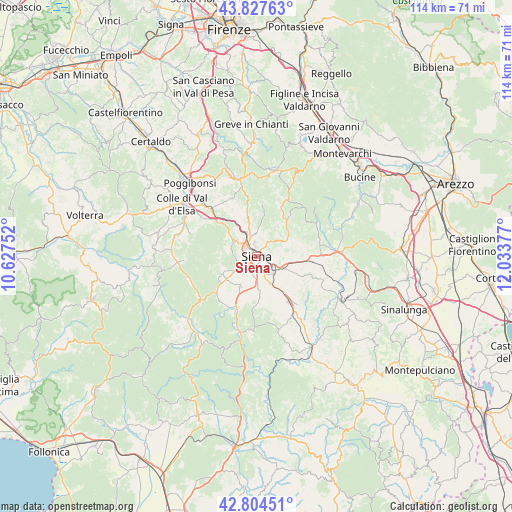
| Map corner | latitude | longitude |
|---|---|---|
| Upper-left | 43.82763°, | 10.62752° |
| Center: | 43.31822°, | 11.33064° |
| Lower-right: | 42.80451°, | 12.03377° |
| Map W x H: | 113.8×113.8 km | = 70.7×70.7mi |
| max Lat: | 47.04031° ⇑61% North |
| Siena: | 43.31822° |
| min Lat: | ⇓39% South 35.50142° |
| min Long | Siena | max Long |
| 6.69888° | 11.33064° | 18.48682° |
| W 47.2%⇐ | ⇒52.8% E |
Elevation
Elevation of Siena is 342 m = 1122 ft, and this is 35.3 m = 116 ft above average elevation for this country.
| Max E: |
2085 m = 6841 ft | 35.1% |
| Siena | 342 m 1122 ft | |
| Avg. | 306.7 m = 1006 ft | |
Min E: |
-4 m = -13 ft | 64.9% |
See also: Siena elevation on elevation.city.
Geographical zone
Siena is located in North temperate zone (between Tropic of Cancer and the Arctic Circle). Distance of this Northern Tropic circle is 2210.6 km =1373.6 mi to South.| Distance of | km | miles | from Siena |
|---|---|---|---|
| North Pole | 5190.5 | 3225.2 | to North |
| Arctic Circle | 2584.6 | 1606 | to North |
| Tropic Cancer | 2210.6 | 1373.6 | to South |
| Equator | 4816.5 | 2992.8 | to South |


Nearby cities:
15 places around Siena: (largest is in red/bold)
• Arbia
7 km =4.3 mi,  113°
113°
• Badesse
8.6 km =5.3 mi,  326°
326°
• Belverde
3.8 km =2.4 mi, 330°
• Castellina Scalo
13.8 km =8.6 mi,  314°
314°
• Isola D'Arbia
7.7 km =4.8 mi,  149°
149°
• Monteaperti
8.2 km =5.1 mi,  83°
83°
• Monteriggioni
11.8 km =7.3 mi, 312°
• Monteroni d'Arbia
12.3 km =7.6 mi,  142°
142°
• Pianella
8 km =5 mi,  60°
60°
• Ponte A Bozzone
4.8 km =3 mi,  44°
44°
• Ponte A Tressa
9.1 km =5.7 mi, 144°
• Rosia
11.9 km =7.4 mi,  227°
227°
• Sant'Andrea A Montecchio
4.6 km =2.9 mi,  212°
212°
• Sovicille
9.3 km =5.8 mi,  243°
243°
• Taverne D'Arbia
5.8 km =3.6 mi,  116°
116°
Sources, notices
• [Note1] Compared only with cities in Italy existing in our database
• [Src1] Map data: © OpenStreetMap contributors (CC-BY-SA)
• [Src2] Other city data from geonames.org with taken over terms of usage.
• [Src3] Geographical zone / Annual Mean Temperature by Robert A. Rohde @ Wikipedia
