Ponte A Tressa geodata
Ponte A Tressa (Tuscany) is a populated place; located in Italy in Europe/Rome (GMT+2) time zone. With population of 1,353 people, there are 5483 cities with bigger population in this country. Compared to other cities in Italy, 61.5% of cities are located further ↑North; 51.9% of cities are located further →East and 58.9% of cities have higher elevation than Ponte A Tressa. Note1


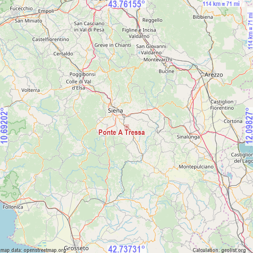
Ponte A Tressa GPS coordinates[2]
43° 15' 5.688" North, 11° 23' 42.504" East
| Map corner | latitude | longitude |
|---|---|---|
| Upper-left | 43.76155°, | 10.69202° |
| Center: | 43.25158°, | 11.39514° |
| Lower-right: | 42.73731°, | 12.09827° |
| Map W x H: | 113.9×113.9 km | = 70.8×70.8mi |
| max Lat: | 47.04031° ⇑61.5% North |
| Ponte A Tressa: | 43.25158° |
| min Lat: | ⇓38.5% South 35.50142° |
| min Long | Ponte A Tressa | max Long |
| 6.69888° | 11.39514° | 18.48682° |
| W 48.1%⇐ | ⇒51.9% E |
Elevation
Elevation of Ponte A Tressa is 172 m = 564 ft, and this is 134.7 m = 442 ft below average elevation for this country.
| Max E: |
2085 m = 6841 ft | 58.9% |
| Avg. | 306.7 m = 1006 ft | |
| Ponte A Tressa | 172 m = 564 ft | |
Min E: |
-4 m = -13 ft | 41.1% |
See also: Italy elevation on elevation.city.
Geographical zone
Ponte A Tressa is located in North temperate zone (between Tropic of Cancer and the Arctic Circle). Distance of this Northern Tropic circle is 2203.2 km =1369 mi to South.| Distance of | km | miles | from Ponte A Tressa |
|---|---|---|---|
| North Pole | 5197.9 | 3229.8 | to North |
| Arctic Circle | 2592 | 1610.6 | to North |
| Tropic Cancer | 2203.2 | 1369 | to South |
| Equator | 4809.1 | 2988.2 | to South |


Nearby cities:
15 places around Ponte A Tressa: (largest is in red/bold)
• Arbia
4.8 km =3 mi,  14°
14°
• Belverde
12.9 km =8 mi,  326°
326°
• Casciano
11.2 km =7 mi,  210°
210°
• Castelnuovo Berardenga
13.5 km =8.4 mi,  39°
39°
• Isola D'Arbia
1.5 km =0.9 mi,  300°
300°
• Monteaperti
8.9 km =5.5 mi,  19°
19°
• Monteroni d'Arbia
3.3 km =2.1 mi,  137°
137°
• Murlo
10.1 km =6.3 mi,  183°
183°
• Pianella
11.5 km =7.1 mi, 8°
• Ponte A Bozzone
11 km =6.8 mi,  350°
350°
• Sant'Andrea A Montecchio
8.5 km =5.3 mi,  294°
294°
• Siena
9.1 km =5.7 mi,  324°
324°
• Sovicille
13.9 km =8.6 mi,  283°
283°
• Taverne D'Arbia
4.8 km =3 mi,  359°
359°
• Vescovado
9.1 km =5.7 mi, 181°
Sources, notices
• [Note1] Compared only with cities in Italy existing in our database
• [Src1] Map data: © OpenStreetMap contributors (CC-BY-SA)
• [Src2] Other city data from geonames.org with taken over terms of usage.
• [Src3] Geographical zone / Annual Mean Temperature by Robert A. Rohde @ Wikipedia
