Urbisaglia geodata
Urbisaglia (The Marches) is a seat of a third-order administrative division; located in Italy in Europe/Rome (GMT+2) time zone. With population of 1,862 people, there are 4392 cities with bigger population in this country. Compared to other cities in Italy, 61.8% of cities are located further ↑North; 72.1% of cities are located further ←West and 61.5% of cities have lower elevation than Urbisaglia. Note1


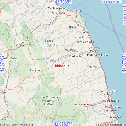
Urbisaglia GPS coordinates[2]
43° 11' 34.944" North, 13° 22' 29.064" East
| Map corner | latitude | longitude |
|---|---|---|
| Upper-left | 43.7035°, | 12.67162° |
| Center: | 43.19304°, | 13.37474° |
| Lower-right: | 42.67827°, | 14.07787° |
| Map W x H: | 114×114 km | = 70.8×70.8mi |
| max Lat: | 47.04031° ⇑61.8% North |
| Urbisaglia: | 43.19304° |
| min Lat: | ⇓38.2% South 35.50142° |
| min Long | Urbisaglia | max Long |
| 6.69888° | 13.37474° | 18.48682° |
| W 72.1%⇐ | ⇒27.9% E |
Elevation
Elevation of Urbisaglia is 311 m = 1020 ft, and this is 4.3 m = 14 ft above average elevation for this country.
| Max E: |
2085 m = 6841 ft | 38.5% |
| Urbisaglia | 311 m 1020 ft | |
| Avg. | 306.7 m = 1006 ft | |
Min E: |
-4 m = -13 ft | 61.5% |
See also: Italy elevation on elevation.city.
Geographical zone
Urbisaglia is located in North temperate zone (between Tropic of Cancer and the Arctic Circle). Distance of this Northern Tropic circle is 2196.7 km =1365 mi to South.| Distance of | km | miles | from Urbisaglia |
|---|---|---|---|
| North Pole | 5204.4 | 3233.9 | to North |
| Arctic Circle | 2598.6 | 1614.7 | to North |
| Tropic Cancer | 2196.7 | 1365 | to South |
| Equator | 4802.6 | 2984.2 | to South |


Nearby cities:
15 places around Urbisaglia: (largest is in red/bold)
• Casette Verdini
6.8 km =4.2 mi,  18°
18°
• Colmurano
3.4 km =2.1 mi,  202°
202°
• Loro Piceno
4.4 km =2.7 mi,  136°
136°
• Massa Fermana
9.7 km =6 mi,  121°
121°
• Mogliano
9.5 km =5.9 mi,  93°
93°
• Montappone
9.9 km =6.2 mi,  129°
129°
• Passo del Bidollo
7.3 km =4.5 mi,  32°
32°
• Passo di Treia
10.9 km =6.8 mi,  341°
341°
• Petriolo
7.7 km =4.8 mi,  65°
65°
• Pollenza
8.4 km =5.2 mi, 344°
• Ripe San Ginesio
5.7 km =3.5 mi,  186°
186°
• San Ginesio
10.5 km =6.5 mi, 204°
• Sant'Angelo in Pontano
10.7 km =6.6 mi,  170°
170°
• Sforzacosta
8.1 km =5 mi, 28°
• Tolentino
7.5 km =4.7 mi,  283°
283°
Sources, notices
• [Note1] Compared only with cities in Italy existing in our database
• [Src1] Map data: © OpenStreetMap contributors (CC-BY-SA)
• [Src2] Other city data from geonames.org with taken over terms of usage.
• [Src3] Geographical zone / Annual Mean Temperature by Robert A. Rohde @ Wikipedia
