Passo di Treia geodata
Passo di Treia (The Marches) is a populated place; located in Italy in Europe/Rome (GMT+2) time zone. With population of 2,368 people, there are 3676 cities with bigger population in this country. Compared to other cities in Italy, 61.2% of cities are located further ↑North; 71.7% of cities are located further ←West and 62.4% of cities have higher elevation than Passo di Treia. Note1


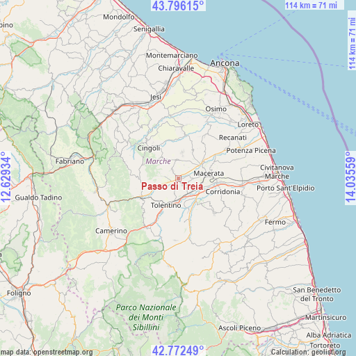
Passo di Treia GPS coordinates[2]
43° 17' 11.292" North, 13° 19' 56.856" East
| Map corner | latitude | longitude |
|---|---|---|
| Upper-left | 43.79615°, | 12.62934° |
| Center: | 43.28647°, | 13.33246° |
| Lower-right: | 42.77249°, | 14.03559° |
| Map W x H: | 113.8×113.8 km | = 70.7×70.7mi |
| max Lat: | 47.04031° ⇑61.2% North |
| Passo di Treia: | 43.28647° |
| min Lat: | ⇓38.8% South 35.50142° |
| min Long | Passo di Treia | max Long |
| 6.69888° | 13.33246° | 18.48682° |
| W 71.7%⇐ | ⇒28.3% E |
Elevation
Elevation of Passo di Treia is 146 m = 479 ft, and this is 160.7 m = 527 ft below average elevation for this country.
| Max E: |
2085 m = 6841 ft | 62.4% |
| Avg. | 306.7 m = 1006 ft | |
| Passo di Treia | 146 m = 479 ft | |
Min E: |
-4 m = -13 ft | 37.6% |
See also: Italy elevation on elevation.city.
Geographical zone
Passo di Treia is located in North temperate zone (between Tropic of Cancer and the Arctic Circle). Distance of this Northern Tropic circle is 2207.1 km =1371.4 mi to South.| Distance of | km | miles | from Passo di Treia |
|---|---|---|---|
| North Pole | 5194.1 | 3227.5 | to North |
| Arctic Circle | 2588.2 | 1608.2 | to North |
| Tropic Cancer | 2207.1 | 1371.4 | to South |
| Equator | 4813 | 2990.7 | to South |


Nearby cities:
15 places around Passo di Treia: (largest is in red/bold)
• Appignano
8.6 km =5.3 mi,  8°
8°
• Casette Verdini
6.8 km =4.2 mi,  125°
125°
• Cesolo
11.6 km =7.2 mi,  255°
255°
• Chiesanuova
5.8 km =3.6 mi,  355°
355°
• Grottaccia
8.2 km =5.1 mi,  323°
323°
• Macerata
9.8 km =6.1 mi,  82°
82°
• Passo del Bidollo
8.5 km =5.3 mi,  119°
119°
• Pollenza
2.6 km =1.6 mi,  151°
151°
• Sant'Egidio
12.1 km =7.5 mi,  56°
56°
• Sforzacosta
8 km =5 mi,  114°
114°
• Tolentino
9.4 km =5.8 mi,  203°
203°
• Treia
3 km =1.9 mi, 323°
• Troviggiano
12.2 km =7.6 mi,  327°
327°
• Urbisaglia
10.9 km =6.8 mi,  161°
161°
• Villa Potenza
8.5 km =5.3 mi, 62°
Sources, notices
• [Note1] Compared only with cities in Italy existing in our database
• [Src1] Map data: © OpenStreetMap contributors (CC-BY-SA)
• [Src2] Other city data from geonames.org with taken over terms of usage.
• [Src3] Geographical zone / Annual Mean Temperature by Robert A. Rohde @ Wikipedia
