Sestriere geodata
Sestriere (Piedmont) is a seat of a third-order administrative division; located in Italy in Europe/Rome (GMT+2) time zone. With population of 838 people, there are 7457 cities with bigger population in this country. Compared to other cities in Italy, 59% of cities are located further ↓South; 99.9% of cities are located further →East and 100% of cities have lower elevation than Sestriere. Note1


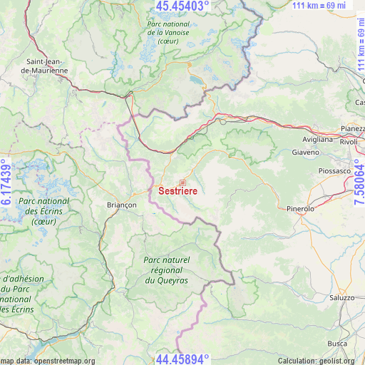
Sestriere GPS coordinates[2]
44° 57' 31.104" North, 6° 52' 39.036" East
| Map corner | latitude | longitude |
|---|---|---|
| Upper-left | 45.45403°, | 6.17439° |
| Center: | 44.95864°, | 6.87751° |
| Lower-right: | 44.45894°, | 7.58064° |
| Map W x H: | 110.6×110.6 km | = 68.7×68.7mi |
| max Lat: | 47.04031° ⇑41% North |
| Sestriere: | 44.95864° |
| min Lat: | ⇓59% South 35.50142° |
| min Long | Sestriere | max Long |
| 6.69888° | 6.87751° | 18.48682° |
| W 0.1%⇐ | ⇒99.9% E |
Elevation
Elevation of Sestriere is 2041 m = 6696 ft, and this is 1734.3 m = 5690 ft above average elevation for this country.
| Max E: |
2085 m = 6841 ft | 0% |
| Sestriere | 2041 m 6696 ft | |
| Avg. | 306.7 m = 1006 ft | |
Min E: |
-4 m = -13 ft | 100% |
See also: Italy elevation on elevation.city.
Geographical zone
Sestriere is located in North temperate zone (between Tropic of Cancer and the Arctic Circle). Distance of this Northern Tropic circle is 2393 km =1486.9 mi to South.| Distance of | km | miles | from Sestriere |
|---|---|---|---|
| North Pole | 5008.1 | 3111.9 | to North |
| Arctic Circle | 2402.2 | 1492.7 | to North |
| Tropic Cancer | 2393 | 1486.9 | to South |
| Equator | 4998.9 | 3106.2 | to South |


Nearby cities:
15 places around Sestriere: (largest is in red/bold)
• Cesana Torinese
6.8 km =4.2 mi,  265°
265°
• Claviere
10.1 km =6.3 mi,  257°
257°
• Colle Sestriere
0.2 km =0.1 mi,  222°
222°
• Exilles
16 km =9.9 mi,  14°
14°
• Fenestrelle
16 km =9.9 mi,  57°
57°
• Massello
14.1 km =8.8 mi,  89°
89°
• Oulx
9.3 km =5.8 mi,  338°
338°
• Perrero
18.6 km =11.6 mi,  96°
96°
• Pragelato-Ruà
7.9 km =4.9 mi,  39°
39°
• Prali
15.7 km =9.8 mi,  119°
119°
• Salbertrand
12.8 km =8 mi,  3°
3°
• Salza di Pinerolo
13.9 km =8.6 mi, 98°
• Sauze d'Oulx
7.7 km =4.8 mi,  350°
350°
• Sauze di Cesana
2.4 km =1.5 mi,  214°
214°
• Usseaux
15.5 km =9.6 mi,  49°
49°
Sources, notices
• [Note1] Compared only with cities in Italy existing in our database
• [Src1] Map data: © OpenStreetMap contributors (CC-BY-SA)
• [Src2] Other city data from geonames.org with taken over terms of usage.
• [Src3] Geographical zone / Annual Mean Temperature by Robert A. Rohde @ Wikipedia
